This article is considered the historical stages of the geoekological situation a river basin of Nura. The main regions of conversion the researching territory are studied. Based on the classification of anthropogenic impacts identified the influence of industrial enterprises on the environment a river basin of Nura.
Anthropogenic factors are caused by various forms of human influences on the individual components of the environment in general and geosystems. They cover the processes occurring in the course of direct human impacts on the environment or indirectly owe their origin technogenesis. Anthropogenic factors — is the impact on nature and the human body (the development of land under crops and crop planting, deforestation, construction of hydro, passive and active foreign importation of various animals and plants, pest control, etc.).
For quantitative and qualitative characteristics of anthropogenic factors using the concept of anthropogenic load. It characterizes the amount of direct or indirect anthropogenic impacts on the environment. Anthropogenic factors are usually related to the side effects of interaction between society and the natural environment. Most often they appear as random, one-time impacts on the natural environment and geosystems accompanying purposeful human activities. These effects may be in the nature of intentional (planned, expected impacts) and unintended (unexpected consequences) impact on geosystems [1].
There are several versions of the classification of anthropogenic of environmental factors developed by different authors. I.P.Laptev offers to classify them based on the following criteria: nature, origin and time of action, for the duration of human impacts, the ability to accumulate in the nature and type of human activity [2].
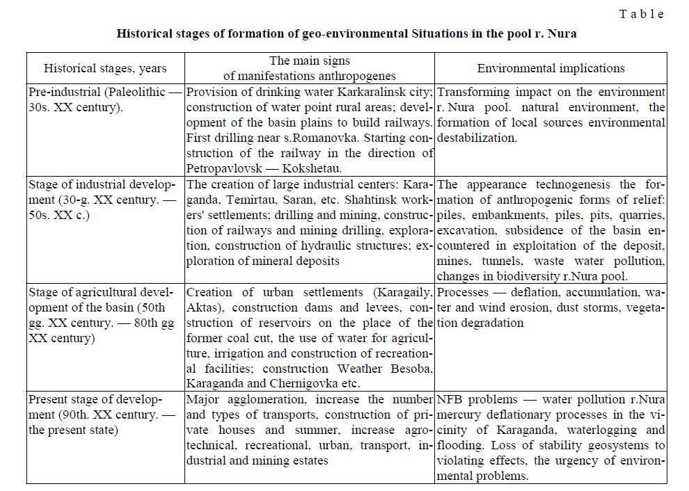
Human impact on the natural environment r. Nura pool can be associated with its industrial development. All studies were conducted in the basin left behind a certain environmental effects. In this connection, geo-environmental situation can be considered at different stages: 1) pre-industrial stage, 2) stage of industrial development, and 3) stage of agricultural development of the basin, and 4) the current stage of basin formation (Table).
Each stage in the formation of geo-ecological situations and gives characterizes a certain picture of development of territories. Each stage reflected recognize the signs anthropogenes — hydrogeological work (drilling, exploration), hydraulic engineering, exploration of mineral deposits, construction of dams, urban planning, etc. Degree of manifestation of symptoms in the pool anthropogenes r. Nura with each step increases, which causes the tension level of geo-ecological situations — from relatively fair to critical.
Pre-industrial stage (Paleolithic — 30th of XX century). Archaeological sites indicate that the basin r.Nura including neighborhoods Karaganda, back in the Paleolithic man lived. He was engaged in hunting, fishing, gathering plant foods. In the Neolithic in the river basin. Nura appear basics of agriculture. Parking this period are found on p. PMCU Late Neolithic — Green bar. Since the 2nd millennium BC (Bronze Age), the ancient population of the region originates pastoral — agricultural economy with a predominance of cattle. This is confirmed by archaeological excavations settlement Suykbulak (Karkaralinsk) and the ancient irrigation system.
Table
Historical stages of formation of geo-environmental Situations in the pool r. Nura
In X-VIII centuries. BC on the territory of modern pool r. Nura develops distinctive Begazy-Dandybay culture. Along with cattle in the pool a crucial role in the development of the productive forces and production tribes played smelting ores.
In stage a major role in shaping the initial geo-environmental impact on the environment is played by holding the fortified lines along the road of the Siberian Cossacks. As a result of these works appear first settlements — village: Karkaralinsk (1824), Ulytau (1841), Aktau (1837), etc. In 1833, A.Baizhanov opens first Karaganda coal, and in 1834 Popov in the tract Berikkara (Karkaralinsk) opens the first and serebrosvintsovye copper deposits. First — Stefanovsky fertile plant in the history of the pool industry r. Nura gave 30 thousand pounds of silver and lead (10 tons of lead per year). In the 80-ies. XIX century. start mining coal deposit in the tract Karagandybasy. In 1886 Ushakov received permission to build a smelter Spassky, 40 km from the Karaganda coal basin. At the end of the XIX century. in the Karaganda coal spear was 500 workers.
Since the late 40s. XIX century. 30-ies. XX century. r. Nura the basin to form local sources of environmental destabilization had Koyandinskaya Fair (Koyandinsko — Botovskaya), which annually conducts auctions. It was located in the river valley near the mouth of r. Taldy oz. Karasor 50 km from the village Koyandy. Creating conditions favorable for the development of regional trade and economic ties Koyandinskaya Fair attracted merchants from Russia and Central Asia. In 1905-1910 years. Department of Land Improvement Resettlement Department conducted surveys to ensure resettlement water points, as a result of which were characterized by surface water and groundwater basins districts Nura Sherubainura, city Karkaralinsk, Balkhash and other, and are the first recommendations for their use. In 1916, near s. Romanovka already received the first information on the stock of the Nura River. River basin studies. Nura started in the first five years of the former Soviet Union, when the territory of Central Kazakhstan were built industrial cities (Karaganda, Zhezkazgan, Balkhash, Shahtinsk etc.).
Analysis of the pre-industrial stage of development of the region shows that economic activity began to have transformative impacts on the environment. During this period there is a change in the geo-ecological situations pool r.Nura from environmental well before the formation of local sources environmental destabi-lization.
Stage of industrial development (30th. XX century. — 50th. XX c.). During the years of Soviet power Karaganda region and become one of the largest industrial centers in Kazakhstan. In 1940, the Karaganda coal basin has 22 mines and 1 uglerazrez (Fedorov). Karaganda coal basin played an important role in the industrial development not only of the Republic of Kazakhstan, but also the whole of the USSR (now CIS) since the Karaganda coal supplied with Enterprise Middle Volga region, the Urals, Bashkiria, etc. The pool was the third coal base USSR. Coalfield development led to the establishment of other industries. For the successful formation of Karaganda region as an industrial center and its water supply in the 30s and 40s. XX century. was built from plumbing r. Nura (Samarkand reservoir). By the end of 33-ies. completed the construction of the Central power, began to build a hydroelectric power station. In 1937 came to operation Karaganda cement plant which annually produces 14 tons of cement. In the same years were commissioned mechanized bakeries, brewery, dairy and other plants in Karaganda. Continued construction of railways through Akmola to Karaganda.
In the early 30s of XX century. in connection with the construction of several large industrial enterprises in Kazakhstan produced hydrogeological studies I.I.Filimonov and D.N.Bourtsev. In the article «Prospects reclamation in Central Kazakhstan» (1930) summarized the materials reclamation expedition in Central Kazakhstan and former subdivisions district land offices, who worked on the rivers Tokrau, Bakanas, Nura and Sarysu [3].
In the future hydrological work in the basin continued hydrogeologists V.Y.Grinyov, S.V.Komissarov, A.P.Vykhodtsev, I.I.Bozhkova etc. (and trust Kargeolbyuro Kazahuglerazvedka). At the same time, except for waters of the Lower Jurassic sediments studied fissure water limestones and volcanics, which is carried by water and rail stations working settlements [4]. At the same time were organized permanent stationary surveillance regime of groundwater in boreholes, mines.
This period coincides with the war and postwar years. After the war, was commissioned and reconstructed 17 powerful mines, including began development of coal deposits in Saran Tentek, Sherubainura, Shakhan. Over the years, coal production in the basin has increased by 62 %, with overall company of the country at 49.8 %, were commissioned 9 mines and coal mines with a total capacity of 24 million tons per year and 4 large concentrators — 3,757 million tons of coal per year.
Extensively has developed chemical industry (Karaganda plant synthetic rubber), which in 1943 began to work first carbide furnace. The largest iron and steel enterprise in the country this stage was Temirtauskiy Metallurgical Plant. Along with engineering plants began to develop the New Karaganda factory, which produced up to 100 items of various machinery and equipment.
Stage of industrial development is characterized not only by the powerful rise of the economy, but also a big shift in the geographical distribution of production: it has become more uniform. There are pockets of industry, watered and incorporated into economic circulation large areas of grassland. Simultaneously implement changes relief dismemberment its network of roads, further transformation regime of surface and groundwater. Observed the development of negative processes: salinity, flooding, wind and water erosion, degradation of soils and vegetation. Issues of environmental management were not implemented in a timely manner, due to weak administrative control right from the relevant departments and organizations for nature protection.
Stage of agricultural development of the basin (50th XX century. — 80th gg. XX in). During these years, the need to expand the resource base for industrial enterprises in the Southern Urals received significant scale geological survey and exploration, as well as hydrogeological work in areas designed and built railroads and mining. This line of work especially increased during the Great Patriotic War. Note some of them. In 1944-1948 gg. Kazgeolupravleniem (M.B.Gamaley, A.A.Emelyanov, V.A.Kurdukov, N.I.Timpani) summarized extensive factual material on groundwater as combined hydrogeological maps, which mainly displayed on the first surface aquifers [3]. These maps form the basis of planning subsequent exploration of the water. In 1946, V.S.Zhavago (Kazgeolupravlenie) were launched, and in 1947-1951 gg. A.F.Kalmykov and I.I.Subbotin continued exploration of water sources for deposits Akmaya, Baynazarov, Celta, etc. In general, the results of hydrogeological investigations before the military carried out the first stage of the assessment of groundwater resources and surface water study region. Revealed the possibility of organizing a centralized water supply of large industrial and administrative centers through groundwater and surface water [5]. In the stage of agricultural development pool r. Nura have been converted to crops virgin lands. There are certain pockets of agriculture. Intensive development of agricultural production led to an increase in agricultural waste, which together with household waste significantly affect the chemical composition of the soil, causing a deterioration of its quality. In this connection there are systems of environmental protection measures, which include prevention of erosion and knitted her Dehumification soils.
The modern stage of development of the basin (90th. XX century — the present state). The most important direction of research and studies in the 70s — 80s of the XX century in Kazakhstan becomes hydrogeoecological with funds and aero-space monitoring, the emergence of which is connected with the resolution of water and environmental problems in the basin of the lake. Balkhash, the Aral Sea, and later, in the 80s - 90s, mining areas, the Semipalatinsk nuclear test site, the Caspian Se, etc.
Important scientific and practical results obtained in the development of Kazakhstan as a deterministic, including analog modeling, which is widely and successfully used in the evaluation of water inflows into mines (mines and quarries) and the calculation of groundwater withdrawals (V.V.Veselov, S.M.Shapiro, T.N.Vinnikov, M.T.Djumagulov, O.V.Podolny, T.T.Makhmutov, M.M.Burakov, V.P.Zolotarev, L.S.Verveykina, R.N.Urmanova etc.), and multivariate statistical modeling and factor analysis of hydrogeochemical and water environmental problems of Kazakhstan (L.M.Paulichenka, K.M.Davletkalieva, A.R.Kurmangaliyeva, etc.), as well as the theory of unsteady filtration inrelation to intakes of groundwater (M.M.Burakov) [6].
After the independence of the Republic of Kazakhstan begins a new stage in the hydrogeological and geomorphological studies of the republic. At this stage the ecological and geomorphological studies of the Karaganda coal basin associated with the study of modern relief processes, anthropogenic relief morphological types of river valleys, the environmental impact of industry on the environment, environmental conditions impact zones Baikonur cosmodrome.
In 1997-1998 gg. studies have been conducted on mercury pollution of the river Nura funded programs Inco-Copernicus, Intas-Kazakhstan and the UK Foreign Office. New INTAS project aimed at the study of microbiological processes, including the formation of methyl mercury in sediments and floodplain soils of the Nura River, currently coordinated by the Institute of Soil Ecology Nyuherberga (Germany) [7].
During field studies were evaluated scale mercury contamination of surface and groundwater data floodplain sediments, soils and soil river valley. Nura and Western industrial zone Temirtau. The same has been done surveying the coast p. Nura bridge in Temirtau (1 km downstream of the dam Samarkand reservoir) to the village. Rostovka (distance 25 km) — every 250 m in 1997-98. studied the effect of external factors on the character of anthropogenic mercury in slag r.Nura microbiological processes sulfate reduction and methylation. The programs conducted study of mercury contamination r.Nura funded programs Inco -Copernicus, INTAS Kazakhstan MFA UK.
In connection with the acquisition of independence of Kazakhstan 's economy began to develop slowly, as in market conditions appeared liability, closed and open society. Many enterprises in the region have started to work on the basis of investment income, the industry is also developing small and medium business (company buying back foreign investors). In 1996, Karaganda confectionery factory was bought by British company «UIG», JSC «Karaganda Candy», Karaganda brewery acquired Efes Beverage Group and formed a venture of FE «Efes Karaganda Brewery», etc. In the present stage of intensive coal industry continues to evolve, which occupies 26.3 % of total productio. According to RU «Tsentrkaznedra» in Karaganda coal basin there were 24 mines, 5 and 7 sections Mining and Processing Plant. In this connection, the concentration of harmful substances in dumps and heaps increased by 3 times. Serious environmental problem is the problem of mine water. Reducing the discharge of saline mine water and demineralization. Reset mineralized mine water leads to contamination of surface and groundwater, waterlogging and salination and large areas of land. Wastewater chemical plants also had a detrimental effect on their surface and internal water investigated territory (Valley Sherubainura). At this stage, there was an increase of anthropogenic pollution r.Nura pool, increase the content of chemical elements and their compounds and particles (mercury, phenol, oil, etc.) in a variety of natural ingredients and littering territories. Worsening environmental problems occurred in some natural areas and the situation became tense crisis.
Analysis indicates that the mining industry has become cause of the intensification of environmental problems in the region. With the development of the mining industry and the chemical industry having piles — mounds dumps. Heaps long time (since the start of operation of a coal deposit and still) pollute the atmosphere, where the ecological and economic damage is not taken into account.
References
- Kochurov B.I. Geography of environmental situations, Moscow: IGRAN, 1997, 15
- Zhangozhina G.M. Novyny for art Nouveau science - 2010: sci.-pract. conf. proc., Sophia: BalGRAD-BG, 2010, 19, p. 64-66.
- Chigarkin A.V. of KazSU. Ser. Geography, Almaty, 1996, 3, p. 3-8.
- Akpambetova K.M., Zhangozhina G.M., Abiyeva G.B. Science and education — the leading factor of strategy of Kazakhstan - 2030: sci. proc., Karaganda: KSTU, 2002, p. 336-338.
- Akpambetova K.M., Zhangozhina G.M. Native geomorphology: past, present, future: Works of the XXX Plenum of the geomorphological commission of the RAS, St. Petersburg: SPbSU, 2008, 184-185.
- Zhangozhina G.M. Poisk,2010, 4, 154-156.
- Library materials of ASE «Karaganda NPZzem», Karaganda, 2008, 23