This article discusses the features of the formation of the buried ancient valleys of the Nura River. Based on power analyzes loose particle size distribution were revealed deposits which are interconnected with modern Quaternary sediments. During the study of the formation of ancient valleys Nura River were studied erosive and accumulative processes affecting the morphology of genetic floodplain terraces of the area. The study identified that the Nura River Basin fully or partially use its valley Quaternary and Pliocene rivers, which have the same direction as the current channel Nura river in Central Kazakhstan.
Creation of modern picture of river valleys equally participate erosive and accumulative processes. The ratio of the latter varies considerably and depends on the common character of the surface and section of the river (intensification of erosion in the mountains and in the upper reaches of rivers, the growth of accumulation in the lowland plains and in the lower reaches of rivers). The main reason is to classify river valleys to fluvial genetic row.
V.V.Dokuchayev [1] the question of formation of river valleys decides as follows: «When normal natural life of the continents on them was always done and will be performed following the cases of the formation of rivers:
- wellhead elongation of the rivers on the one hand with the help of rain the river with another — uplift coast;
- through the connection of the lakes: first, with the sea, secondly, with other lakes and thirdly, with the adjacent rivers;
- through direct treatment of lakes in the river».
River valleys there are as old as the continents crossing them. Over time changed the outlines of continents, ranged their height and hydration, respectively which were born and disappeared the river valley.
Given the age and history of the river valley are divided into:
1) modern;
2) ancient;
3) great-valley;
4) fossil valley [2].
Under the present valleys implies floodplain, bordered by the river wash away, the native slope and one or two lower terraces. Chronologically the development of modern valleys coincides with postreplication-Holocene time. In Central Kazakhstan the lower terraces of the modern valleys are composed of alluvial Sands [3].
Ancient valleys include the whole series of morphologically expressed terraces. Many rivers are fully or partly use their nijnecheljustny valley and Pliocene predecessors, flowed in the direction close to the modern one. These may be Great-Nura, Great-Sherubainura. Morphologically, great valley may not always be expressed on the ground, in some areas they are at the present watersheds. Age limits, great rivers are highly variable, but are close enough for large regions with similar features in the geological history. The fossil river valleys of different ages. From the geological point of view, they include and very old age valleys. According to V. I.Goretsky (1982), is morphologically on the ground they are not expressed. The key to cognition is the study of their fossil alluvium, lithology, facies, types.
Among the sufficiently large number of classifications deserve special attention developed by I.S.Shchukin (1940) classification of the stages and cycles of development, and on the internal structure and topography. These classifications are morphological and genetic framework of the landscape of the valleys [4].
Detected buried river valleys in the plain, especially typical for platform areas. These ancient valleys are made by younger sediments and therefore, the process of their evolution, in the usual sense, finished completely. The topography of the river valley is expressed in the form of elongated depressions with gently sloping chain of lakes, dry logs. There is very often coincide in the direction of modern rivers with small deviations. Their structure is also the same as in modern valleys is the channel, floodplain, terrace, outcrops of the flow.
Buried valleys of Central Kazakhstan were first discovered in exploration drilling for water in 30-ies of XX century. The modern relief of this territory is the ultimate plain — as a result of prolonged failure of rock structures in conditions of continental denudation. It is known that with the end of the Paleozoic area in Central Kazakhstan has consistently stayed in the continental phase of its development. Since the Paleozoic mountains were razed to the ground. Modern rivers are shallow, many dry lands in the upper reaches of the river dry up in summer (Nura, Ishim). Often they do not reach the main river, flow into a small lake, which is especially characteristic of the tributaries of the Irtysh. Their valleys are broad, flat, small depth of 5–10 m, width — up to 5–10 km away. All it says is that the rivers and valleys of this area are signs of decay, they are in a late stage of its development.
Ancient buried valleys associated freshwater, placer deposits of minerals. According to S.S.Voskresensky (1968), if you add up the numerous descriptions of ancient buried valleys in Central Kazakhstan, can be seen different by origin of education. On the one hand, as the ancient valley is considered to 25–35 km lowering, with proluvial slope, lacustrine, and only to a small extent alluvial deposits. The power of unconsolidated sediments (up to roof folded Paleozoic basement) in the valleys of the uneven. In areas of elevations, dominated by proluvial-slope sediments, it is measured 4–10 m.
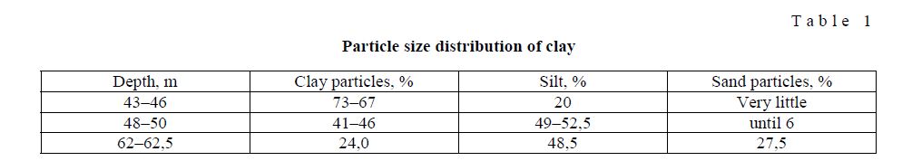
Closer to the periphery of the Central uplift of Kazakhstan and close to Nur-Teniz basins and sarysuiskii power loose thickness increases to 100 and more meters. Among them, begin to dominate lacustrine, deltaic-fluvial and river deposits, and often at the base overlain by lacustrine siltstones and Sands of the Aral Suite. For example, in a granulometric composition of clays for the district Sherubainura according to
- Levina [5] is dominated by clay particles (Table 1).
Particle size distribution of clay
Т a b l e 1
The structure of the ancient valleys of Central Kazakhstan are not enough studied yet. Their depth is up to 100 m, usually filled by three horizons of sediments. At the top are Quaternary sediments up to 70 m — loams, Sands and gravel-pebble material. Below is variegated gypsiferous clay are second horizon, dominated by red, yellow, greenish with a mixture of sand, gravel and pebbles with a capacity of up to 80 m. the third horizon, which lies on the Paleozoic base, represented by sand, pebbles, with a capacity of 3–20 m. In all horizons of sediments of buried valleys of the Central Kazakhstan are gravel and pebbles. This speaks to the complexity of the terrain, the presence of the mountains and very violent river flows.
In the areas of distribution of the ancient valleys there is almost complete coincidence in their modern river network, also match the watersheds. The river retain the flow direction. Floodplain partially displaced with respect to the ancient pereplavleni performed by alluvium. But sometimes there are traces of a substantial restructuring, confined to areas of permanent immersion and accumulation.
River valleys of Central Kazakhstan is characterized by the presence of epigenetic plots, the occurrence of which is associated with the intensive cutting of rivers after performing the precipitation of the valleys to a considerable height [2]. On denudation plains and low mountains characterized by epigenetic parts of the river valleys. In these areas of the valley are much reduced in flow patterns are observed in the outcrops. According to S.S.Voskresensky (1968), the ancient bed of the valleys are found some way away and separated from the modern valleys, rocky ridges. Length of epigenetic plots sometimes greater than 10 km, but usually less [4].
The study of ancient valleys of Central Kazakhstan, it can be concluded that the long-term integrity and heredity modern rivers is attributable to the following factors:
- in the long process of denudation in the origins of the riverbed are never «destroyed» completely, because bed erosion rate is always greater than the planar denudation. This contributes to their preservation and inheritance of the rivers in the future;
- the valleys are routes for transporting solid material that also promotes long-term conservation;
- the preservation of ancient valleys and their associated inheritance that is very slow movement of the earth's crust, especially in platform areas compared with the speed of bed Therefore rivers apparently never lose their channels, their direction of flow, only a few being displaced in some cases and prisposoblenie to different structural elements of tectonics: the grabens, faults, resets, etc.
Thus, we can say that the modern platform of the river plains of Central Kazakhstan are almost always in the limits of the ancient valleys. They are associated with them their «roots», the watersheds, the General direction of flow, the structure, i.e. they are continuations or remnants of ancient rivers. Determining the age of ancient sediments encounters some objective difficulties because the valleys are rarely preserved any fossils. Bone remains of animals in the river flow often fray and disappear completely. In Central Kazakhstan, a plurality of valleys, but in any case not found paleontological remains. So their age is determined conventionally, various authors in different ways. N.G.Cassine (1936) attributed them to the Jurassic, G.T.Medoev (1956) and A.S.Sarsekov (1958) [3] considered Pliocene, Z.A.Svarichevskaya (1965) stretches their age from the Cretaceous to the Quaternary period [5], etc. In the future, based on the analysis of the fauna of ostracods, Z.T.Levina (1953) [6] classifies them by the Pliocene. Thus the age of buried valleys, there is conventionally in the range of million to 60 million years.
For the first half of the upper Pleistocene accounts for the last alteration of the hydrographic network of Central Kazakhstan. At this time, ceased to exist some valleys (for example, Karasor-Early-Windom and Sherubainura-Cap-Esen) and in their place was formed of the river North-South direction, radiating from the centers of maximum uplift. The age of the valleys of the studied region coincides with the age of the rocks composing them. Valleys are generally developed slightly earlier than filling their precipitation, which can be repeatedly accumulated and eroded again. Even if not blurred, the development of the valleys themselves occurs earlier in a cycle of erosion than the sediments, that too will take time. This equally applies to any valleys, as ancient and modern. This is especially important for Central Kazakhstan, as the region for a very long time was under peneplanation. Rainfall valleys in the lower part are often coarse-grained, which is associated in some way with mountainous terrain. Buried valleys of Central Kazakhstan were incorporated in late Paleozoic time in the Mesozoic era of alignment, a small uplift in parts of this area did not violate the plan of the river network. Valleys can be filled up, then eroded and filled up again, because since the inception of these valleys more than 300 million years. The watershed still has never changed its location in connection with a modern network is almost identical with the ancient. The researchers note that the elevation of the Central Kazakhstan together with the topography of the valleys is undergoing late stage development, and the mountains of the South-Eastern part of Kazakhstan and Central Asia, young — era of neotectonics.
Essential composition composing the rocks. In the buried valleys of the Central Kazakhstan are usually fine-grained, variegated clay and red clay of weathering crust. It — sediments of lowland rivers, which have been accumulated slowly and for a long time with a weak stream of water. If peneplanation took place, and the relief took place here hundreds of millions of years, it is obvious that there will be mostly clayey sediments. Even if was coarse-grained material, it for a long time was destroyed, being exposed to chemical degradation, which contributed to the accumulation of multi-colored clays. The ancient alluvium R.GreatSherubainura known from the works of V.A.Kurdyukov (1957), Z.T.Levina (1955), A.S.Sarsekov [7] and other researchers. According to Yu.S.Malinovshi (1960), the basal gravels found throughout the valley of the Great-Sherubainura.
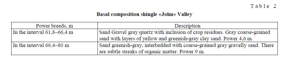
Compared to the same ancient alluvium Nura river, the basal gravels Sherubainura are more rude staff. The sand thickness varies from 20 to 35 m. the target Gurtskoj dam the power of the ancient alluvium is 23 m Below capacity grows to 28 m. The bandwidth of the Sands of the hills Karamuryn is 1750 m, near the hills of Sherubay — 3400 m, Gurtskoj below the dam is 2 km away. the Sole of them is located at a depth of about 80m below the present surface of the river bed Sherubainura. Accordingly, the direction of ancient valley band departs from the basal Sands of the valley of Sherubainura modern West [4]. There they perform the so-called «valley Jons», first described by V.A.Kurdyukov (1957). The incision of the basal strata is as follows (Table 2).
Basal composition shingle «John» Valley
Т а b l e 2
Thus, the study of the ancient valleys Nura river and Sherubainura lets say that the ancient valley study area made by younger sediments (mostly valleys buried under fluvial-alluvial sediments). Some noticeable connection between the ancient valleys with relief and structural elements of the area. The presence of ancient rocks and the highest point in the origins of rivers indicates that the origins of ancient rivers also was at the same places where the modern start of the river. The bottoms of ancient valleys are broad and flat and the cutting depth of about 100 m and is made of meso-Cenozoic sediments.
References
- Dokushaev V.V. Composition, Мoscow; Leningrad: Nauka, 1949, 1, p. 136–138.
- Report of Yu.S.Маlinovski, Мoscow: Nauka, 1961, p. 32–78.
- Shchukin I.S. Problem physical geography, 1940, 9, p. 21–22.
- Voskresensky S.S. Geomorphology of the USSR, Мoscow: Vysshya shkola, 1968, p. 157,
- Svarishevskay A. Geomorphology of Kazakhstan and Middle Asia, Leningrad: Leningrad State University, 1965, p. 142.
- Levina Z.T. of KazSSR Academy of Science, 1953, 11, p. 111–114.
- Sarsekov A.S. of KazSSR Academy of Science, 1958, 3 (156), p. 74, 75.