Just within the Karkaraly state national natural Park (KSNNP) allocated 8 main habitat types pines on a number of similar ecological characteristics combined into 4 groups Association pine granite hills by 8 illustrations. Group 1 — there is rock outcrops, devoid of soil cover. Group 2 — there is rocky-stones slopes with poor, mostly fragmentary soil cover. Group 3 — there are accumulative transit landforms with a close relative developed soil cover. Group 4 — there are floodplain permanent streams in mountain valleys with a powerful soil cover on alluvial sediments.
Interaction in the community between plants and the environment is very complex. Formed a community is not a random combination, but is one that evolved in the process of evolution over the centuries, where plants are adapted to the joint growth under natural conditions. An essential feature of plant communities is the nature of the habitat, i.e. the environmental conditions of the community. Almost characterizing the habitat community note: the geographic location, altitude, terrain (exposure slope microrelief, moisture and the like), soil conditions, interaction with the environment. In turn, the environment is a complex set of environmental factors acting on plants [1].
The mountainous terrain has so large a differentiating impact on the climatic conditions and physical geographical processes that spatial differentiation of landscape in the mountains is extremely complex.
The abundance of forms of meso- and micro-relief and the uneven distribution of soil lead a large variety of environmental conditions, and as a consequence flora of lowland has a specific character.
The main criteria for the selection of habitat types accepted: position in the vertical section of the terrain, the degree of development of soil and moisture conditions [2].
The content of these criteria are complex biocenotic relationships that link all components of the ecological community into a single, evolving in space and time, self-regulating system, all parts which interact with each other and in substantially each other cause [3].
Field work was carried out by the method detailed route survey area with the photographing and recording of the selected parcels, including a description of the landscapes in test points, taking into account interactions of the basic components of the landscape (topography, soils, vegetation, moisture regime, etc) [4].
Based on the collected data lined up profiles in the study area to determine the ecological framework of the habitats of pine.
Just within the Karkaraly state national natural Park (KSNNP) allocated 8 main habitat types pines on a number of similar ecological characteristics combined into 4 groups Association pine granite hills.
Group 1. There is rock outcrops, devoid of soil cover. There are extremely harsh and dry conditions.
This group types characteristic of the granite hills and gives them the landscape is kind of dramatically different from the typical appearance of hills and smoothed hills. Usually occupies the most elevated parts of the relief, although in isolated outcrops occurs on slopes up to the foot of the mountains. The soil cover is virtually absent or rudimentary.
This group includes two types of habitats pine that differ in the character of the addition of rock, which detects the presence of soil and vegetation physiognomy.
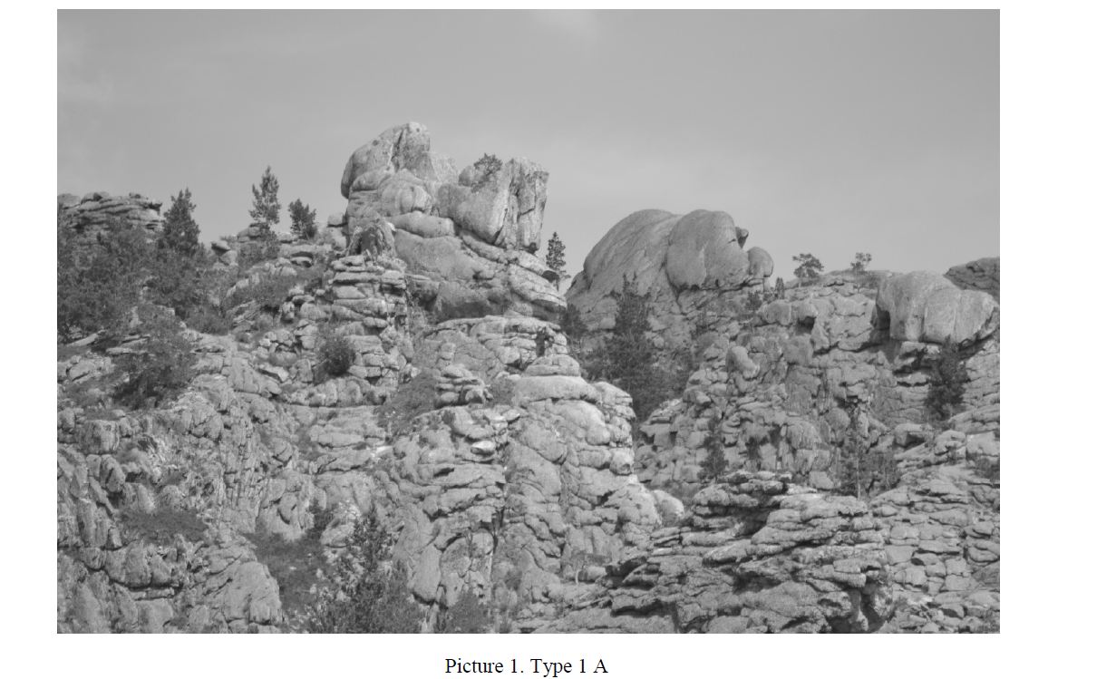
Type 1 A. There is rock outcrops in the watershed and individual outliers' massive addition, devoid of soil cover.
This type is characteristic for the individual hills and ridges massive or the type of addition of large rocks boulders. The slopes have different slope, relatively weakly dissected, however, may have a more complex shape, forming peaks, quaint «pillars» and « tower». In surface cover is dominated by crustose lichens.
On rare cracks and fractures filled with fine-grained deposits occur steppe herbaceous xerophytes and petrovici, Cossack juniper (Juniperus sabina) and a single, pine, showing the striking simplicity to habitat conditions, spreading to the highest peaks and rocky ridges. In these conditions it is characterized by very slow growth, often has a dwarf sizes and often takes a creeping or close to it form (picture 1).
Type 1 B. There is rock outcrops in the watershed and individual outlier's similar to the mattress or as stratiform micro blocks with the beginnings of soil cracks. This type differs from the above well-pronounced fragmentation of the rocks, often in the form of layering on each other thin plates and reservoirs. More in comparison with the massive granites addition, the number of cracks and fractures between the layers and blocks contributes to the accumulation of fine-grained deposits. However, the soil here is rudimentary. Relative soil cover does not exceed 0.1 to 0.2 cm. The average depth of loose substrate is 4-5 cm, individual faults — to 20-25 cm. High the position of the relief are cause instability of the hydrological regime. The main source of moisture here is precipitation. There is vegetation in these conditions greatly thinned. The tree layer is represented by pine with a small admixture of birch warty. Plantings are formed scattered trees are very weak growth (50-200 per 1 ha). The average height of Mature stands does not exceed 3-4 m and the weight is less than 3-5 cm. The efficiency of such plants is the lowest, 5 B. the site.
Pine in these conditions never form closed stands because of the extremely weak growth of trees, although in some cases the number of trees in recalculation on 1 hectare reaches 800-1000 PCs.
The scarcity of growth conditions (extremely limited rhizosphere and chronic lack of moisture) and the open nature of the stands often result in curvature of the trunk and education squat they had to traverse the crown. All this gives grounds to determine the described type of woody vegetation as real rocky woodlands (crooked). The shrub layer is typically dominated by juniper Cossack.
Scattered meet oppressed deciduous shrubs: meadowsweet (Spiraea hipericifolia), cotoneaster black (Cotoneaster melanocarpa), small-leaved honeysuckle (Lonicera microphylla), caragana (Caragana frutes), barberry Siberian (Berberis sibirica). Grass cover strongly izrezhen, projective cover does not exceed 0.4 units 0.2 total area.
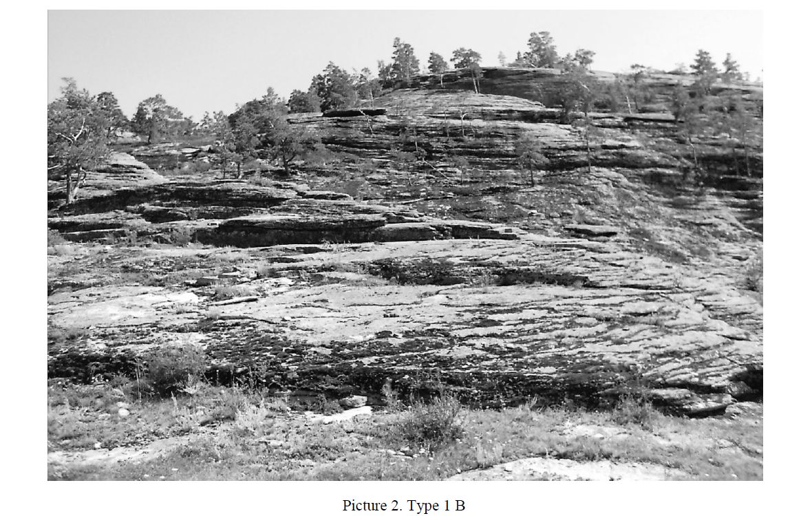
Dominate petrovici — Sedum hybrid (Sedum hybridum), homoclinic prickly (Orostachys spinosa) and xerophytes — Veronica gray (Veronika incana), and others (picture 2).
Group 2. There is rocky-stones slopes with poor, mostly fragmentary soil cover.
Poor and partly moderately rich vegetation, very dry and dry conditions. This group types occupies the slopes of varying steepness and exposure. The soil cover is formed on aluvia-diluvii granite, is very uneven in depth and often fragmented. The abundance of elements meso- and microrelief and cracks in the bedding rock creates favorable conditions of flow, which is almost completely converted into the subsurface, and clay.
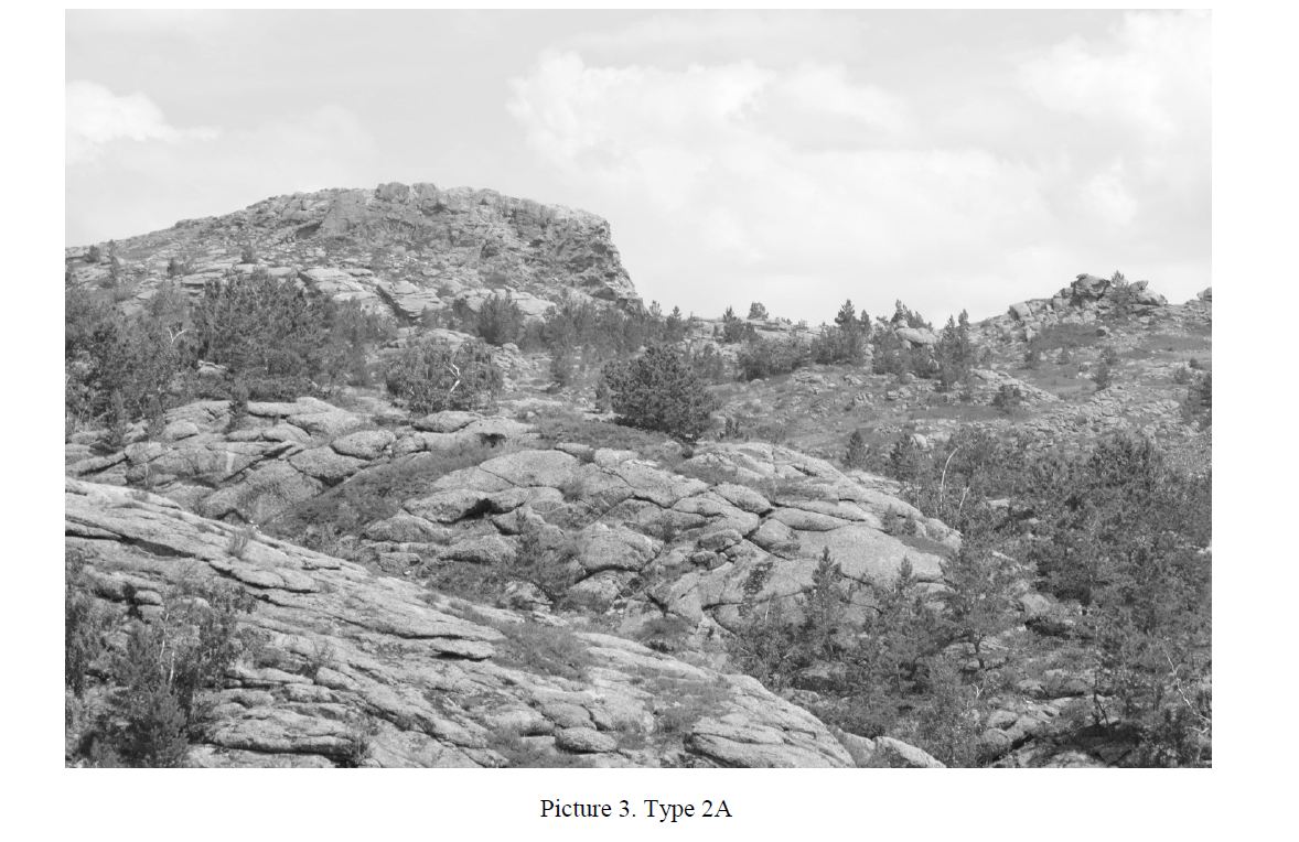
This group includes 2 types of habitats that differ in the degree of development of soil cover. Type 2A. There are rocky slopes with granular soil cover.
Plots of this type are usually confined to the upper or middle part of the slopes of the average slope and low slope, rarely take the flattened watershed and a small plateau. Relative soil floor is 0.3-0.6 unit area average power friable soil 9-15 cm, in some places up to 50-60 cm. Due to frequent outcrops of rock on the surface of the soil cover is not closed, fragmented, and soil profile for the most part has no genetic horizons.
Woody vegetation on the plots of this type is usually represented by sparse pine with a small admixture of birch warty, rarely aspen, with the number of trunks from 50 to 500 for 1 hectare. Valuation metrics of trees of the same age vary greatly due to the large variability of individual growth conditions. The average height of forest stands does not exceed 5-7 meters, average diameter at breast height is 8-14 cm. The completeness of such plantings, as a rule, less than 0.1 to 0.2 unit area, and the supply of stem wood does not exceed 10-30 cubic meter per hectare. The growth of a stand of this type relates to 5-5A site classes. The shrub layer is often dominated (where it is not destroyed by fires) juniper Cossack.
Absently and small groups there tavolga, cotoneaster black, rose colocasia (Rosa spinosissima), caragana, barbaric Siberian, occasionally currant dougla (Ribes diacantha).
Grass cover is sparse, the projective cover ranges from 0.3 to 0.7 unit area. This is prevails cleanings hybrid.
A large part in the cover and take other petrovici — homoclinic thorn, Veronica gray, cat's paw and xe-rophytes — fescue, meadow grass steppe (Poa stepposa), bow drooping.
In the developed moss layer dominated by genera Polytrichum piliferum. Of the most common lichen Cladonia sylvatica, much less meet Cladonia rangiferina and Cladonia alpestris (picture 3).
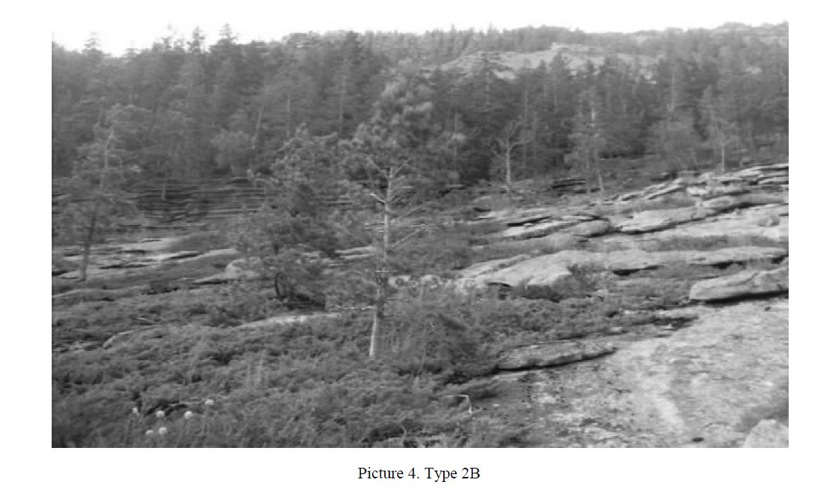
Type 2B. There are rocky slopes with relatively closed soil cover.
Plots of this type occupy the middle and lower slopes of a small slope with relatively calm relief. The soil floor reaches of 0.7-0.9 6 unit area. The power of the loose soil of the ground is uneven, on average, 15-25 cm, sometimes up to see 60-110 cm. Genetic horizons in most cases is clear. Stands of pine in this type of highly thinned (30-150 trunks on 1 ha), and often nonexistent. The trees here reach larger sizes than in the above-described type (average height of 7-10 m, a diameter of 15-18 cm). Some trees 15-17 m and diameter up to 60 cm. On sites of this type are large field's steppes. Grass cover is well developed, the projective cover reaches 0.6-0.8 parts per 1 sq. m. There is dominated by fescue-sagebrush- feather Association with the admixture of steppe grasses. Significant distributions are above deciduous shrubs found absently and small groups. Juniper Cossack in these conditions is rare (picture 4).
Group 3. There are accumulative transit landforms with a close relative developed soil cover.
There are moderately rich and rich, moderately dry and moderately wet conditions. This group brings together three geomorphologic element low: between a rock depressions, hollows ephemeral streams and trails of the mountains, which are the batteries deluvial sediments and runoff. From the above types are more favorable soil and hydrological conditions. Woody vegetation, usually completely absent on temporary drains and is present only on the slopes..
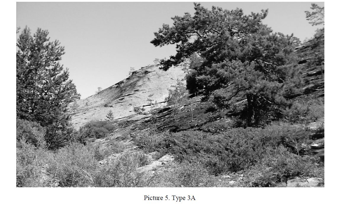
Type 3A. There are between rocky depressions with a thin soil cover. Plots of this type are concave landforms between outliers and small hollows in different parts of the slopes. Are specific to granite hills with a well-developed torso of the meso-relief and usually occur in conjunction with habitat groups 1 and 2. The soil cover is formed on the deluvial sediments weathering products of granite, covering the bottom of the depressions. There are relative soil coverage of 0.9 to 1.0 unit area, the average power profile 25-40 cm, increasing to the center of the lower up to 60-80 cm and more.
The depth of the soil profile does not have such a sharp variation, as in group 2, and genetic horizons are usually clearly expressed.
Such habitats are usually firmly occupied a well-developed steppe and meadow-steppe vegetation with high projective cover (up to 0.7 to 0.9), often with a large part (up to half cover) deciduous shrubs (picture 5).
Type 3B. There are hollow ephemeral streams with a closed soil cover average power.
Plots of this type occupy a narrow bottom elongated hollows and shallow ravines. From parcels type 3 and differ deeper embedded, strong direction and a larger catchment area. Are temporary streams during snowmelt and heavy rainfall. The soil cover is closed (relative coverage of 0.9 to 1.0), the average power profile of the soil 30-60 cm, reaches thalweg troughs 100-150 cm and more. For vegetation is dominated by shrubs, mainly hips and meadowsweet, which often form closed thickets (picture 6).
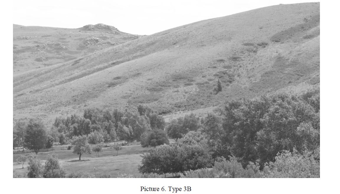
In the lower tier is dominated by multi-species meadow and meadow-steppe associations with high projective cover (0,8-1,0).
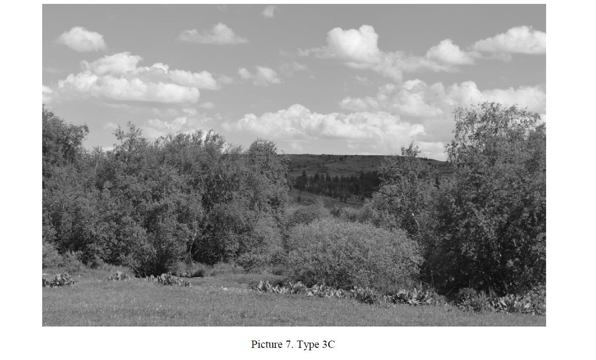
Type 3C. There are plumes mountains with a relatively thick soil cover.
Due to the short length and steepness of slopes, and the weak development of erosion processes plumes granite hills is strongly reduced and occupy a narrow strip at the foot of the mountains. The soil cover is formed on the deluvial sediments weathering products of granite, closed, and its capacity reaches 60-100 cm or more. Hydrological conditions are relatively favorable due to the accumulation of soil runoff from adjacent clones.
On sites of this type is dominated by meadow-steppe and shrub associations with high projective cover (picture 7).
There are floodplain permanent streams in mountain valleys with a powerful soil cover on alluvial sediments. There are rich, moist and wet conditions.
Plots of this type of narrow ribbons are found along streams and small rivers on taloga gorges and valleys with a relatively large catchment area. Soils are deep, often waterlogged. Are areas of constant excessive moisture.Are dominates closed tree and shrub vegetation. There is most typical birch chopping involving aspen, less pine density plantings.In the undergrowth and forest edges are growing shrub willow, hawthorn, Siberian, cherry plain, black and red currant. For ground cover typical stone berries pyrda media, water-loving sedges and mosses (picture 8).
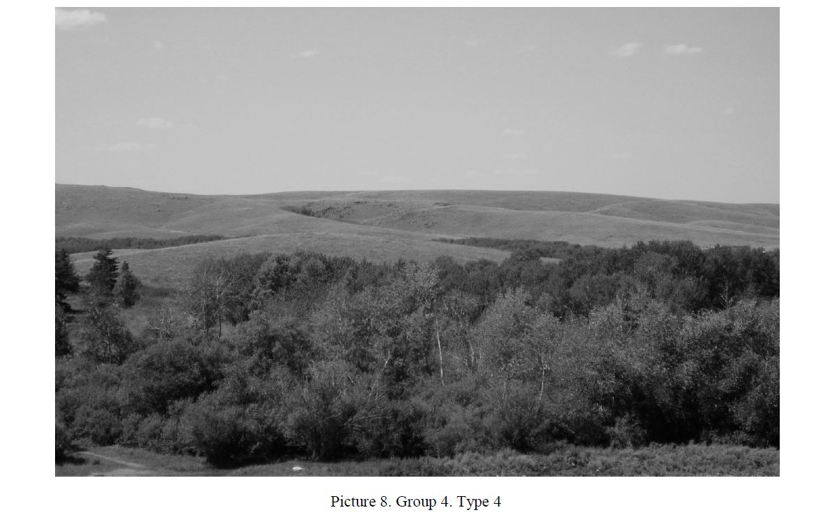
Group 4. Type 4.
Despite the fact that have been allocated eight types of habitats pine, this division is conditional, as the parts distribution pines more diverse and it is often impossible to attribute to any type.
Each studied plot, attributed to one of these types is a mosaic (micromosaic) plant communities are often peculiar to the area (zone) and absent in others. For example, the slopes facing North, colder and better hydrated, soil on them more powerful and, consequently, the vegetation is more diverse.
A large number of factors influencing the growth of pine requires careful study of its habitat over the years. The data obtained in our study will give an initial starting point in the subsequent observation of the growth of pine in KSNNP on the marked polygons observations.
References
- Yaroshenko P.D. Geobotany, Book for students the teacher training colleges, Moscow: Prosveshchenie, 1969, 200
- Geldyeva G.V., Veselova L.K. Landscapes of Kazakhstan, Almaty: Gylym, 1992, 175
- Belikovich A.V., Galanin A.V., Tregubov O.D. Nature and resources of Chukotka, Magadan: SWSC FEB of RAS, 1997, 62-76.
- Isachenko A.G. Landscape science and physical-geographical zoning, Moscow: Vysshaya shkola, 1991, 366