Modern Kazakhstan deserts for many geological epochs were areas of the Earth's crust immersion. As a result, there marine and continental powerful unconsolidated sediments have accumulated. The alternation of the sediments indicates a change in repeated transgressions and regressions of the sea caused by centuries of slow vertical oscillation of the land. The complexity of the geological structure of Kazakhstan conditioned by participation of the different rock complexes. The age of rocks varies widely. Paleogeographic history of the arid zone shows the relation of the present topography of the arid zone with ancient geological structures
Arid zone of Kazakhstan covers the northern half of the Caspian depression, Mugodzhar hills, southern part of Turgay plateau and Kazakh uplands, Zaysan depression. In the south, it is limited by the foothills of the Tian Shan, Dzungarian Alatau, Saur-Tarbagatai mountain system and the state border with the CIS countries (see Table, Fig. 1).
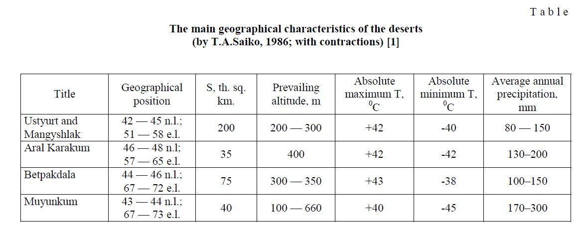
The main geographical characteristics of the deserts (by T.A.Saiko, 1986; with contractions) [1]
T a b l e
Modern deserts of Kazakhstan were areas of immersion of the earth's crust for many geological epochs. As a result, there marine and continental powerful unconsolidated sediments have accumulated, the alternation of which indicates the replacement of repeated transgressions and regressions of the sea, caused by the slow secular vertical oscillations of the land. The complexity of the geological structure of Kazakhstan is caused by participation of different rock complexes, age of which varied within wide limits.
The most ancient rocks of the Pre-Paleozoic stage detected in the Mugodzhar hills, in the southern part of the Turgai depression, within the Atasu-Mointy watershed. In the Western Balkhash Precambrian deposits are widespread in small areas. Its outcrops are confined to a narrow fault blocks. They are known in the hole Karakamys, Sarytum tectonic zone and presented by Precambrian formations: granite-gneisses, crystalline schists, sandstones. Cambrian deposits have limited distribution. They are composed two narrow tracts extending in a northwesterly direction. The first tract stretches along the southwestern foothills of Shu-Ili mountains. Spatially it coincides with Zhalair-Naiman deep fault. The second, or Sarytum, traced from the south-western end of Lake Balkhash to the north-west. The lower part of the Cambrian is represented by porphyries, tuffs of basic composition, tuff-sandstones. The middle part consists of tuff-siltstones, tuffites and tuff-conglomerates. The upper part is represented by limestones, conglomerates and grits. In General, in the Cambrian, most of the territory of Kazakhstan was represented by the sea, above which towered the islands arising as a result of Caledonian orogeny. To the west of the island arcs was located land, which occupies part of the Caspian depression and Ustyurt [1].
In the Ordovician geological regime any fundamental changes have not been undergone. Eastern outskirts of Kazakhstan is a complex archipelagos of islands, erosion of which leads to the accumulation of clay and siliceous sediments. Ordovician deposits are widely developed in the central parts of Kazakhstan, represented by sedimentary and volcanic rocks. In the western Balkhash their outcrops reach out along Sarytum zone of fracture to the south of Kaib granite massif to the Balkhash lake. In Zhalair-Naiman flexure sedimentary deposits is dominated, with a thickness of 200–300 m., formed at the base of the carbonate facies, changing higher by terrigenous formations. In Sarytum flexure in the Ordovician effusive activity was intensely manifested. Thickness of effusive-sedimentary sequence is about 900 m. Deposits of average part distributed along the southern coast of the Akkerme bay and are represented by gray, light gray sandstone and siliceous shales.
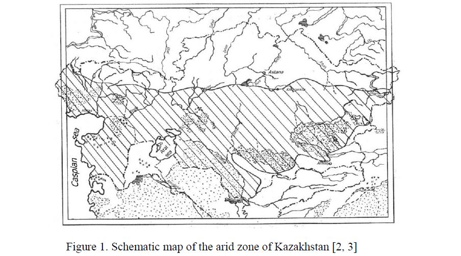
Figure 1. Schematic map of the arid zone of Kazakhstan [2, 3]
The upper part of the Ordovician period established by Upper Caradocian superstage and Ashgil stage. Deposits of the Upper Ordovician are characterized by facies uniformity. Numerous lenses of limestone and conglomerates with small unsorted pebbles are in Sarytum flexure. End of Lower Silurian was marked by the manifestation of a powerful folding. From the sea bottom have been raised new ranges, which increase the area of previous islands. In other areas, on the contrary, zone of intense subsidence and sediment accumulation was revealed. During the Upper Silurian areas which are occupied by sea, was gradually decreased and by the end of the Silurian sea conditions had already appeared in small areas. From coast of the Balkhash lake in a northwesterly direction to the tract Karakamys reef limestones reach out by two lines. In the area of Lake Kashkanteniz to Upper Silurian sediments interbedded sandstone, siltstone, calcareous sandstones attributed. Intrusive activity related with the tectonic movements of the upper Silurian. More ancient implementation of magma were expressed by ultrabasic and basic rocks. To later phases of folding granodiorite and plagiogranite intrusions confined. In the beginning of the Devonian sea was only in the north of Mugodzhar hills and Dzungarian Alatau. Continental conditions prevailed in the rest of the territory. They had occupied an extensive area from the Akkerme bay to the Saryshagan bay. Lower Devonian deposits are distributed to the south-west from the st. Mynaral and north of Kashkanteniz lake. The upper pack is composed of volcanics, to which joined basalt porphyrites near the snaps. Formations of lower-middle part extend from coast of the lake Balkhash in a northwesterly direction to a dry riverbed Kyzylespe. Redterrigenous rocks bared to the west of the bay Akkerme. Thickness of volcanics of Lower-Middle Devonian, filled with a variety of extrusive and subvolcanic solids, represent the porphyry formation of Late Caledonian imposed volcanic belt. Its formation is completed in the Late Devonian-Early Carboniferous by introduction of large granitoid intrusions. Upper Devonian deposits are represented by terrigenous formations and divided into marine and continental-lagoon sediments [2].
Intense tectonic movements of Carboniferous turned the unstable movable area of sedimentation in the eastern outskirts of Kazakhstan's to the territory with well-expressed tendency to uplift and denudation. Carbon deposits in the Mugodzhar hills presented by coal-bearing facies, changing in the upper horizons to the limestones. In Turgay depression formation of carbon consist of limestone, porphyrites, tuffs. In the western Balkhash region carbon material is marked in small superimposed troughs — Kashkanteniz, AkzharSarytum, Karakamys, Mynaral, Kyzylkemer, Kulanketpes and Alakol. Tournay deposits of lower division are known in all the troughs of Western Balkhash (Fig. 2).
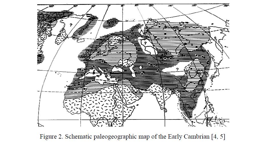
Figure 2. Schematic paleogeographic map of the Early Cambrian [4, 5]
They are represented by sandstones, siltstones, limestones and conglomerates, composing wings of Kashkanteniz, Akzhar-Sarytum, Karakamys and Mynaral synclines. Favorable conditions for the accumulation of coal-bearing strata has created in the border zone of immersion between Caledonian structures in the Western part of the Kazakh uplands and an area of increased development of Hercynian structures, located to the East. In this area there was a powerful thickness of coal-bearing sediments of the Karaganda coal basin. In Perm there has been a sharp differentiation of tectonic movements. Geosynclinal regime almost the entire territory of Kazakhstan passed to the platform. In the interest to us zone sea conditions are preserved only in the Caspian depression, in the west of Mugodzhar hills, on Mangistau plateau. In the Caspian depression Permian deposits are represented by salt-bearing strata, overlain by brightly-colored layer of PermianTriassic formations.
The Permian sediments of the Caledonian orogeny in the Central parts continue Carboniferous sediments, represented by sandstones, siltstones and freshwater limestones. In Zhezkazgan depression marked lower Permian salt-bearing sediments. In the Balkhash region the cut of Perm formations is expressed by continental volcanic-clastic formations. On Mangyshlak plateau continental red deposits are replaced by saliferous-lagoonal deposits in the Caspian depression (Fig. 3).
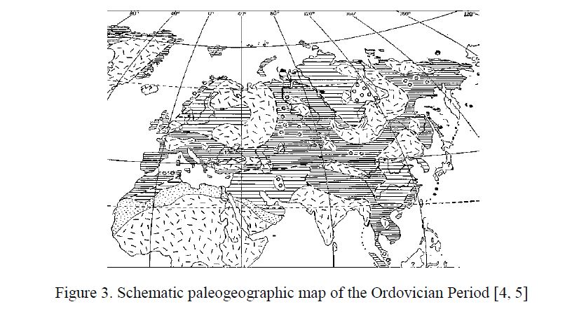
Figure 3. Schematic paleogeographic map of the Ordovician Period [4, 5]
In the geological history of development of the Earth Triassic is the period, when the land was most widespread, and sea conditions are preserved in narrow strips of geosynclines. However, the western part of Kazakhstan at that time was still under the influence of the sea regime. In Mangistau’s Karatau thick strata of Triassic marine sediments are marked. In the area of Lake Baskunchak detected outcrops of conglomerates, sandstones and clays of the Triassic age. On the remaining area continental conditions have existed. On the territory of Kazakhstan Triassic climate was characterized by alternating of pluvial and xerothermic periods. In the west sea transgression has a softening effect on the climate. End of Triassic marked a noticeable increase in humidity and development of abundant flora, what has caused the accumulation of coal-bearing strata. In Jurassic continental regime was observed in most parts of Kazakhstan. In the middle and upper Jurassic sea conditions observed in the west. Lower Jurassic deposits in the Ural-Emba region and Mangistau plateau are represented by the accumulation of river and marine sediments. In areas adjoining to Mugodzhar hills, in Turgay depression, in the central parts, in the Karatau range and Mangistau plateau accumulation of sediment was continued. At the end of the Middle and the beginning of the Upper Jurassic sedimentary cover of Turan plate was formed. From that time until the end of the Miocene sea repeatedly occurred on the territory of the Turan plate. The late Cretaceous and Paleogene transgression were the most extensive. Arid and hot climate of the Triassic replaced by humid climate of Jurassic.
The weathering crust of this period is characterized by light-colored, because warm and humid climate contributed to the emergence leached and bleached siliceous or kaolin rocks.
In the Cretaceous sea conditions are preserved in the south-west of Kazakhstan. The most wide dissemination sea receives in the Upper Cretaceous. At this time, the entire western part was exposed to the Upper Cretaceous transgression. In the Caspian depression Lower Cretaceous sediments are mainly marine. Characteristic feature of the Upper Cretaceous is the white writing chalk. The climate of the Cretaceous is characterized by dryness. However, wide dissemination of red color sediments and processes of formation of bauxites, indicate the alternation of dry and wet periods (Fig. 4).
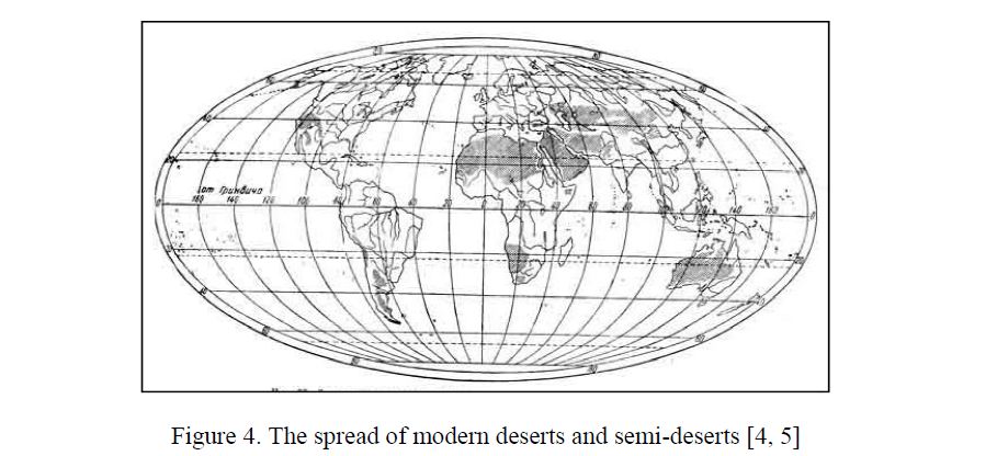
Figure 4. The spread of modern deserts and semi-deserts [4, 5]
Continental conditions in the early Oligocene was marked in the Mugodzhar hills, Kazakh uplands and in the South-East of the country. Paleogene deposits are widespread in Ustyurt, in Turgay depression, in the Aral Sea region and in the Karatau. Paleogene sea occupied territory along the northern margin of Kazakhstan. From the Aral region sea was spread to the North, washing in the West Mugodzhar hills, on the East — Kazakh uplands. The composition of the Paleogene deposits is characterized by variegation. In the West accumulated sands with glauconite, in the North — siliceous formations, in the South — carbonate sediments and clay. From the middle Oligocene the long process of the Alpine folding, sea regression, rising of the land began. The climate becomes drier.
Neogene period is characterized by the transgression of the Sarmatian sea, the remnants of which are the Black and Caspian seas. The Eastern shore of the Sarmatian sea extends from the southern outskirts of the Mugodzhar hills and modern Aral sea to the lower Tedzhen. Extensive lowlands, formed on the place of the departed Paleogene sea, were composed of river, wetland and lake sediments. On higher parts, there was an accumulation predominantly of brown and red clay material. In the Neogene began renewal of river activities, and modern hydrographic system was formed to the end of the period. In earlyand mid-Pliocene time Caspian Sea existed as two isolated basins. The sea, which occupied the South Caspian depression, fed by waters of paleo-Amudarya, and the sea of Middle-Caspian depression fed by waters of paleo-Volga. In the beginning of the late Pliocene was aridization of the climate of aligned spaces of Central Kazakhstan, where instead of woodland and semi-savannas have any significant areas of steppes and deserts.
In the Quaternary period there were repeated fluctuations in the level of the Caspian Sea. Baku, Khazar and Khvalynsk transgression captured the western part of the Turan plate. The most significant was Khvalynsk transgression. During this period, the Caspian Sea level rose for 50 meters above the present, and the sea spread up to 560 east longitude. Quaternary deposits are developed everywhere. They are very different in coloration from the more ancient deposits of gray and yellowish-gray, reflecting the changing of climatic conditions in the direction of cooling. In the Caspian basin the lower Quaternary deposits are represented by marine sediments. On the plains of Turgay Lower Quarternary formations embedded in the ancient valley of Pliocene age. Mid-Quaternary sediments spread wider, and formed themselves into already heavily changed conditions. Mountains climbed, ruggedness of the terrain increased. The increase of humidity caused the whole complex of terraces. In comparison with the more ancient, they are better expressed in the relief, but in relation to young, enough changed by subsequent tectonic and denudation processes. Upper Quaternary sediments begin by sediments of xerothermic epoch — eolian sands of Kyzylkum, Muyunkum, South Balkhash and the Aral Sea region. Lacustrine deposits fulfilled both ancient and young depression.
Modern formation are represented by variety of genetic types. In the Caspian depression in the Holocene series of fluctuations in the level of the Caspian Sea was followed. All sea level fluctuations are marked by complexes sediments forming of terraces and ancient beach ridges.
References
- Babaev A.G. Desert, Мoscow: Мysl, 1986, 318 р.
- Akpambetova M. Geomorphology of arid regions of Kazakhstan: training manual, 2, Karaganda: Publ. KSU, 2002, 113 p.
- The Atlas of Kazakh SSR, Moscow: Main Department of Geodesy and Cartography under the USSR Council of Ministers,
- [ER]. Access mode: fotki.yandex.ru.
- The World Atlas, Мoscow: Main Department of Geodesy and Cartography under the USSR Council of Ministers,