The article is devoted to questions of ecological state of water resources in Central Kazakhstan. The geo- ecological state of the small rivers catchment on the example of the River Karkaralinka is considering. It de- scribes the physical and geographical features of the river catchment. The study identified natural and anthro- pogenic factors affecting the river basin, also held geoecological analysis of the contaminated area.
The provision of natural systems in areas of small rivers is the main indicator of the condition of the whole system. Different changes affect the hydrological regime and also entail a chain of changes on large rivers. Any river system is an independent azonic territorial unit and its size is characterized by a specific set of geosystems. The combination of these characteristics presenting hydrological and hydrochemical indicators of the river system which determined by hydrological indicators in each part of the river. Small and medium-sized river basins always remain out of sight of researchers, regardless of whether the main indicator of ecological situations in the region. The state of small rivers the main source of livelihood of locals, so we examined this on the example of Karkaraly river which flows through the land of Karkaralinsk.
The river starts from the Karkaralinsk mountains, flows through Karkaralinsk town and through the low mountains territory flows into the plain near Karasor. The length of the river from source to sea Karasor 85 km, the catchment area of 640 km2.
The upper current of the basin Karkaralinsk river flows through the eponymous mountain, the average current through the valley foothills and the lower current across the plain near the river [1]. Therefore, the basin is located on the branches of the 3 climatic zones. Here, of course, the Karkaralinsk meteorological station (MS) well describes the mountain zone. Also since it is located on the northern slope of the moun- tains it can be considered as the foothills area. The third zone is near the Besoba meteorological station which is located at the distance of 110 km south-east from Karkaralinsk by height and climate of the meteor- ological station. As the result, characterizing the climate of the basin was selected Karkaralinsk meteorologi- cal station (height above sea level 810 m) which is stable since 1935 with a break 1894–1930.
The number of days of clear weather on the territory by the total degree of cloud cover on average 80 days. Cloudless clear days is 45 % in summer. The total flow of solar radiation during the year is 110 kcal/cm2, the albedo in the warm period is 28 %, in the period of snow cover is 70 %. The total radiation balance is 42 kcal/cm2. The highest temperature usually in July. The coldest month is January. An absolute minimum of frost — 45єC was recorded in 1919. The maximum daily amplitude of air was recorded in November is 27.9 єC, the minimum fluctuation within one day in October is 0.9 єC. The first frost is observed on 4th September, sometimes in the middle of August (1944 year). The average frost-free period is 95 days. Average monthly absolute humidity varies during the year in January and February from 1.8 hPa (MB) to 11.5 GPa in July. Relative humidity for several months, fluctuate from 75 % in December to 56 % in June. Dry days is an average is 77 days per year.
Precipitation mostly very little in the form of rain (less than 0.1 mm) or snow. The number of days when layer of precipitation not more than 0.1 mm — 11 days in average, not more than 1 mm — 62 days, not more than 10 mm — 6 days, not more than 30 mm — 0.3 days. On average, a day of falling snow cover — October 16, rstable cover is formed about November 17. Sometimes the formation of snow cover occurs in the third decade of October or can last until the end of December. In the spring the snow begins to melt in mid-April and sometimes lasts sometimes until the end of may, if the spring is warm ends in late March. According to the results of field studies of snow height of about — 18 mm, the highest — 32 cm. Density of snow cover is 215 kg/m3.
Most often in Karkaralinsk in the winter often blows South winds. In summer the winds blowing straight to the North, West and South directions. In general, it was recorded that in an average year the predominant are South and southwest winds The most windy months are October and November, the average monthly wind speed of 4.2 m/s.
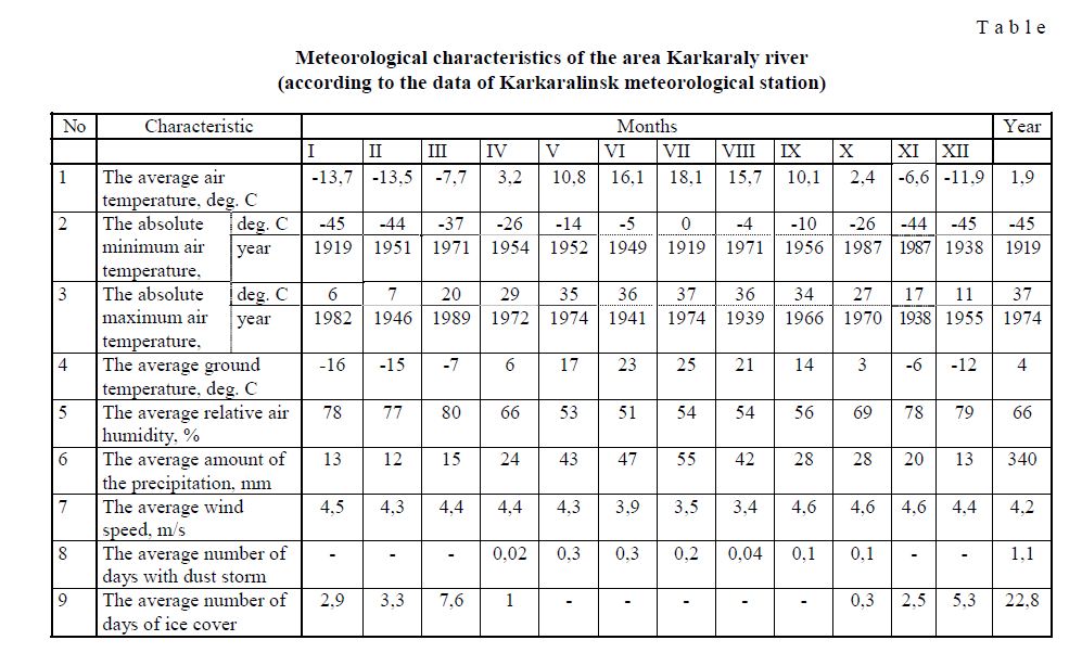
Detailed information about the weather of the study area is shown in Table, compiled on the basis of data of Karkaralinsk meteorological station [2].
Meteorological characteristics of the area Karkaraly river (according to the data of Karkaralinsk meteorological station)
T a b l e
Relief. The upper current of the river is located within the Karkaraly mountain massif with a height of 1050–1150 m. Then the river flows past mountains of Karamurza (1064 m), Karazhal (872 m), Siirly (833 m). Down from the mountain Siirly occur bumpy hills with a height of 700–720 m. the Lower current passes through the plain with a height of 675–625 m. In general, the surface of the basin tilted to the North [3].
The basin geological structure belongs to the zone Tekturmas hill Djungar-Balkhash system. In rocks dominated: effusive-sedimentary complexes of the Proterozoic and granitic complexes of the Paleozoic, alluvial complexes of the Cenozoic. Hydrogeological zoning of the territory belongs to Tekturmas zone (split water area of the Tekturmas hill). Zone of Tekturmas covers the northern part of the geosyncline Djungar- Balkhash which is more elevated in contrast synclinorium Karaganda which surrounds the north and Uspen synclinorium in the south: in the west the zone borders with the Central Kazakhstan fault, which divides Djungarian-Balkhash geosynclinal from the Chingiz geosyncline zone, then the area follows to the northern slope of the Balkhash-Tengiz watershed (Fig. 1).
Upper quaternary alluvial-deluvial, saline and lake sediments are common in the narrow openings which lie along the riverbeds Karkaraly river. Dominated chloride-sulphate sodium water with mineralization of 5–24 g/l. Chloride-hydrocarbonate calcium waters with mineralization of 0.3–1.2 g/l are common in the upper part of the valley in well drying places. Unstable regime and the random distribution of groundwater limits the practical significance of alluvial-proluvial-deluvial sediments. Groundwater of the lake rocks follow to the terraces, that surround Karasor lake by a narrow strip (width up to 1 km).
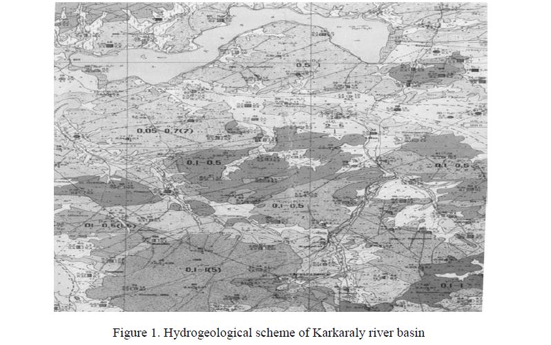
Figure 1. Hydrogeological scheme of Karkaraly river basin
Lower alluvial quaternary — recent sediments’s water horizon which developed in modern river valley. The depth of water level varies in the pasture part from 1.5 m and in the surface of the pasture up to 6 meters. The thickness of the water horizon in average 10–12 m. Groundwater by the quality is mainly fresh water, total mineralization of up to 0.4–1 g/l. The water horizon of alluvial quaternary is the source of the water supply of many settlements, livestock, mining.
Water accidentally distributed deluvial-proluvial pliocene upper — upper quaternary deposits are developed in the sides of the valley, in depressions between hills and in the cones. The thickness of the water layer of deluvial-proluvial sediments varies between 0.5–5m. The mineralization of water is different and varies to 0.3–6 g/l, salinity is 1–2 g/l, dominated water with compositions of bicarbonate-sulphate-sodium or chloride-sulphate calcium. Despite occasional spread and increased mineralization of water, they are widely used for water supply of small farms and for water animals in the wintering.
Water of open fractures where dominated lower carboniferous volcanic-lower permian deposits are widespread on the territory of the syncline structure Bugyly, Kushoky, Konkashty and Karazhal. As a rule, the depth of water in the cracks does not exceed 4 m. Fresh water with a total mineralization of 0.2–0.5 g/l are found everywhere. The chemical composition is hydrocarbonate calcium, sometimes hydrocarbonate- sulphate calcium [4].
The basin of the Karkaraly river in the landscape-soil map of Karaganda region belongs to the dry steppe zone, to the point of moderately dry steppe dark pink soil. Widely distributed imperfect dark pink soil can transmit water. These include various dry prairie grass, fescue and feather grass vegetation. Fescue and feather-grass vegetation are spread in usual dark pink soils formed from clay. In the lower current of the basin of river are spread salted dark pink soils. There are different steppe sagebrush species and groups of xenohaliotis. In the mountains Karkaraly grow pine forests on granites of perm.
The fauna of the basin Karkaraly river varied because it is located in steppe and mountain areas. The flora of the steppe zone have influenced to the wide distribution of steppe marmots, jerboas, and others. In the mountains are argali, roe deer, deer, wild boar, wolf, fox, lynx. Ornithological associations to include steppe, black and white-winged larks, white-headed cranes, steppe eagles. In the mountainous areas inhabit bat, black stork, golden eagle, common kestrel, grey swallow, mongolian desert bullfinches and others. There are invertebrates, locusts, various beetles, insect larvae and crayfish in the ponds. From reptiles there are lizard painted snakes, steppe vipers, copperheads [5].
With regard to hydrological condition, the river throughout its length receives relatively several large distributary: on the right bank — Karaozek (from the mouth 67 km, a length 11 km), Tulkili (61 km and 11 km) and Zhartas (38 km and 17 km), on the left side falls only one river Tasbulak (57 km and 10 km).
The volume of water which flows through the river is formed mainly from melt water, sometimes from rain and groundwater, including springs of Karkaraly mountains and foothills. The flow of water decreases rapidly in the lower current of the river Karkaraly, because it fills small lakes on the floodplain of the river.
During the floods in the upper current on the average passes 78 % of the flow. In some years during the flood, the annual flow amounted to 100 % (1976 year) sometimes 34 % (1963 year).
The basin Karkaraly river refers to the 1 zone of turbidity (50–100 g/dm3) on the map of turbidity of rivers Karaganda region, the state of erosion is estimated by the coefficient A=0,009. The average consumption of the alluvium in the river near the village Pervoe Maya is 0,077 kg/s, average turbidity — 23 g/m3, annual flow of alluvium is 2.4 thousand tons. Obviously, this maximum strong flow along the length of the river. The maximum turbidity of the river is observed at the output from the Karkaraly mountains.
In the spring the water temperature at 0.2°, as a rule, takes place in the first decade of April. The maximum temperature in July average temperature is 22є. The first ice formations appear in the autumn on average in the first decade of October. The freeze-up occurs in the beginning of November. In some years the freeze-up occurs in mid-October, sometimes may not be until the end of November. Spring ice phenomena on average start at the beginning of April and ends in mid-April. In the years when water is scarce, most of the ice masses melt on the spot. The ice thickness reaches an average value (90–100 cm) in mid-March. Maximum ice thickness can be up to 140 cm. When the floods reached the limit of river’s water, which was formed in wet conditions and which freezes in autumn, has bicarbonate-sodium properties, mineralization 300–350 mg/dm3. If the floods are formed in dry, well-filtering soils, then sulphate-sodium properties of river’s water felt fuzzy, mineralization is 500–600 mg/dm3. At the end of floods in the composition of the water increases the ions of sodium and sulfuric acid, mineralization increases up to 800– 900 mg/dm3. In summer and in winter, when the water availability is very low mineralization reaches 2–6 g/dm3, the ion composition is dominated by Na, Cl and SO4 [6].
Riverbed of the Karkaraly river extends on the territory of Karkaraly district of Karaganda region. The majority of the population living on the banks of the river engaged in agriculture. Lands located in the area of the river (except the territory of the Karkaraly town and Karkaraly state national natural park), usually used for this purpose. It's pasture, hay and cropland. To the unsuitable lands relate barren pastures and land used in technological processes (mines, settlements, pumping stations, pipelines, roads, quarries for the production of building materials). To the urbanized areas relate constructions, buildings and other objects, as well as areas unsuitable for use in agriculture are the remnants of construction materials, garbage, heaps of cultivated lands, destroyed structures, ravines and other.
The total area of water protection zone of the Karkaraly river — 7839,8957 ha, including the water protection strip 1814,8005 ha (by the data of the Nura-Sarysu basin inspection).
As noted above, people living along the river in addition to livestock are also engaged with irrigate crops for planting potatoes. Private homes of the Karkaraly town use the river water for irrigation of household lands.
In many reference books is said the Karkaraly river to end near lake Dat. But as a result of our research and mapping work we identified that the river flows into the lake Karasor (in some years). To assess the ecological situation of the Karkaraly river we divided into III zones:
From the source of the river to the territory of Karkaralinsk, the population of people is low. Now in this area located the idle hospital. Previously, the hospital sent waste water into the river. The problem of the wastewater should be considered before the start of the object as a specific technical project, that considered the assessment of damages to the environment. The project should be decided jointly with the SES and environment protection bodies. Petrol stations «KazMunayGas», «Zharas» and «Nur», which are located on the right and left sides of the road Karaganda-Karkaralinsk at the entrance to the city located in the water protection zone. Petrol stations are not equipped with the system of storm sewer. Generally, the coast is high and precipitous, where in some places grow the grasses and shrubs and sloping coast framed by meadow vegetation. The relief consist from the hills which have some differences in height. The signs of the absolute height, in the upper part of the city (north-west) 895 m, in the lower part of the city (south-east) is changed to 820 m [7].
Former grain receiving point located on the north-east of the city and is not currently functioning partially included in water protection zone. The riverbed within the city was subjected to strong anthropogenic influence, unlike other parts of the river. In the upper, north-west of Karkaralinsk, the river divides into two riverbed. Private houses built along the banks of the river are located closely. Here are the dried part of the riverbed in some places, in spite of surface flow on the entire surface.
All part of the territory from Karkaralinsk town to the village Akzhol takes only one settlement, it is village Akzhol. The riverbed in this region is obvious. Only in some parts is observed that there is no surface flow. Shore is mainly flat, but also found a high steep places. There are also hills of different heights. Signs of absolute height in the Karkaraly region is 820 m, near the village of Akzhol changed to 683 m. On the banks grow willows shrubs, herbaceous and shrubby plants. A significant portion of the river is located along the road linking the village Akzhol and «Karaganda-Karkaralinsk» road. During the research we noticed diffuse pollution sources (building materials, household waste, manure pile, etc.) are found on the banks and riverbeds of the river located within the village (Fig. 2).
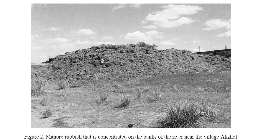
Figure 2. Manure rubbish that is concentrated on the banks of the river near the village Akzhol
Overall, this study area Karkaraly river was subject to minor anthropogenic impacts. Now the sanitary condition of the two banks of the riverbed which located outside of the village can be characterized as favorable.
Sparsely populated area of the river from the village of Akzhol to the mouth flowing into the lake Karasor, here found only a few adjacent wintering. In all parts of the river has no surface flow, the river channel (riverbed) is poorly developed and in the area of the river Dat flow is lost. The coastline and the riverbed is covered with herbaceous and shrubby plants. The signs of the absolute height of the riverbed 683 m (village Akzhol), changing to 625 m at the mouth of the lake Karasor.
Also the economic activity of people has some connection with settlements (village Akzhol on the banks of the river, and also in villages located at the distance, Koktas and others) and with adjoining agricultural lands.
The study concluded that in areas located near the riverbed of Karkaraly river population of people is poor and uneven. The maximum population density in the valley of the river is observed in the town of Karkaraly which is located in the upper current of the river. Below along the current of the river is only one settlement village which is called Akzhol (village named after M.Mamayeva). Comparatively in the study area intensive anthropogenic development began with the founding of the town of Karkaraly.
The above features, in particular, the result of agricultural production activities of the population, also the livelihoods of habitants of settlements located on both banks of the river are cause the load to the river.
References
- Karagandy region: encyclopedia, Almaty: Atamyra, 2006, 584 p.
- Materials collection of Karkaraly meteorological center, Karagandy region,
- Kaulambaev Z. Geomorphology of the Karkaraly lowland-finely-of volcanic district (Central Kazakhstan): abstract. dis. ... cand. biol. Sciences, Alma-Ata: Kazakh SSR Academy of Sciences, 1972, 31 p.
- Falevich I.E. et. al. Hydrogeology of the USSR, XXXIV, Karaganda, CKGM; Karaganda hydrogeological expedition, 1967, 701
- Physical Geography of the Republic of Kazakhstan: tutorial / Edit. M.Dzhanaliyeva, Almaty: Kazakh University, 1998, 262 p.
- Surface water resources of the Hydrological studies, 13, 1, Central Kazakhstan. Leningrad: Gidrometeoizdat, 1965, 215 p.
- Akhpambetova K.M., Abiyeva G.B. of the KSU, Ser. Biology, medicine, geography, 2009, 3 (55), p. 82–86.