The aim of this study is to detect hot spots of anthrax predicting the risk of human infection and farm animals' anthrax contamination. We evaluated clustering of anthrax soil foci using methods of spatial autocorrelation. We illustrate that anthrax active and not active foci were geographically clustered in the southwest across the study area. High-High and High-Low clusters suggest that clusters of active foci are persistent in two oblasts of the south. They are in the Kazygurtskiy, Baydibekskiy rayons of the South-Kazakhstan oblast and Zhualinskiy rayons of the Zhambyl oblast that represent single node of anthrax outbreaks emergence.
Introduction. Background.
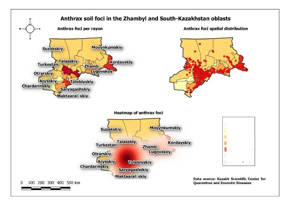
The Zhambyl and South-Kazakhstan oblasts (provinces) have the highest anthrax risk in Kazakhstan. About 90 % of both human and animal outbreaks of anthrax are found in these regions of Kazakhstan. However, density of anthrax foci in different rayons is heterogenous.
Aim of the study.
The aim of this study is to detect hot spots of anthrax predicting the risk of human infection and farm animals' anthrax contamination.
Methods. Terms used.
We define a soil focus of anthrax as a burial place for a farm animal(s) that died from anthrax.
We consider a soil focus of anthrax as active, if a person or a farm animal has been contaminated with anthrax in it during last 5 years.
Data source and study area
Field teams of the Kazakh Scientific Centre of Quarantine and Zoonotic Diseases collect data in anthrax foci in the rayons (districts) of the Zhambyl and South-Kazakhstan oblasts (species and a number of farm animals contaminated with anthrax, a number of died animals) and precise coordinates of foci during 2003 - 2014. Of the 1805 anthrax foci, we included into dataset 1326 where animals had died of anthrax.
Data analysis. Dataset development.
A GIS database was constructed to evaluate spatial patterns of anthrax foci in the Zhambyl and Southern Kazakhstan oblasts. Foci points were aggregated to rayon (district) level to allow for spatial autocorrelation analyses. In addition, we aggregated foci points within the one km hexagonal grid cells.
Spatial statistical methods
- Conceptualisation of spatial relationship (Average Nearest Neighbour's analysis) was used to evaluate clustering in rayons. Every rayon is assumed to be a neighbour of other rayon, and the influence of rayons decays with increase distance.
- Global index of spatial autocorrelation (Moran I) was used to assess spatial dependencies across rayons with respect to anthrax foci presence. The Global Moran's I statistic is evaluated in terms of a null hypothesis that anthrax foci are spatially randomly distributed across rayons. Rayons are deemed to be a cluster of either High-High (i.e. high number of anthrax foci per polygon surrounded by high numbers), Low-Low, High-Low, or Low-High values relative to neighbouring rayons. The null hypothesis states that there is no spatial autocorrelation or association of foci between districts.
Software.
Quantum GIS of version 3.0.3, an open source GIS application, was used to construct spatial databases and for data visualisation. The Global Moran's I, Getis-Ord GI*, LISA analyses were conducted in GeoDa, version 1.12.1.139 (http://geodacenter.asu.edu/).
Results.
Heatmap of anthrax foci distribution weighted farm animals deaths in them is illustrated that the highest rates are in the southwestern portion of the study area (Kazygurtskiy, Baydibekskiy and Zhualinskiy rayons).
Using the Average Nearest Neighbour's analysis, we detected clustering of 1326 anthrax soil foci in southern region of Kazakhstan (z-score: -63.03; p = 0.001). On average, the observed mean distance between foci was 731.4 metres (Figure 1).
 Among foci with farm animal deaths, there's less than 1 % likelihood that clustered distribution of 1303 farm animals deaths in these foci is due to chance (the Average Nearest Neighbour's analysis: z-score: -62.34; p = 0.001). On average, the observed mean distance between foci was 753.9 metres.
Figure 1 - Anthrax foci spatial distribution in southern Kazakhstan
|
Foci |
per rayon |
|---|---|
|
О |
0-0 |
|
о |
1 -190 |
|
о |
191 - 380 |
|
1 1 |
381 - 570 |
|
■ |
571 - 760 |
|
■ |
761 - 950 |
Using Global Moran I analysis, we detected clustering of anthrax foci (Moran's I: -0.0470, p-value = 0.008).
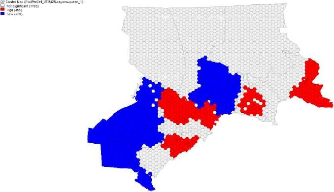
Four hundred fifty five one km2 hot spots of active anthrax foci were detected using the Getis-Ord GI* analysis (with 1st order Queen Continuity matrix) in four areas (Figure 2).
Figure 2 - The spatial distribution of active anthrax foci
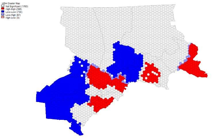
LISA defined 388 High-High and 67 Low-High clusters of anthrax Kazakhstan oblasts (Figure 3).
foci in the southwest rayons of the Zhambyl and South-
Figure 3 - LISA-based cluster maps of active anthrax foci
Here we illustrate that anthrax active and not active foci were geographically clustered in the southwest across the study area. High-High and High-Low clusters suggest that clusters of active foci are persistent in two oblasts of the south (Figure 4). They are in the Kazygurtskiy, Baydibekskiy rayons of the South- Kazakhstan oblast and Zhualinskiy rayons of the Zhambyl oblast that represent single node of anthrax outbreaks emergence.
LISA based cluster map of athrax foci in the Zhambyl and South-Kazakhstan oblasts
Figure 4 - Rayons of high risk of anthrax contamination
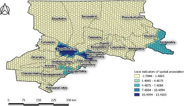
This may identify key areas for animal intervention, such as culling or vaccination. These areas also should be target areas for human intervention, such as education programs or efforts to identify animal handling or slaughter practices that may increase risk.
Acknowledgments.
This study was supported by the Field Epidemiology and Laboratory Training Programme of the Centres for Disease Control and Prevention in Central Asia Region, Kazakhstan.
We would like to thank Amber Dismer, Health Scientist from the Emergency Response and Recovery Branch of Centers for Disease Control and Prevention, for her kind assistance in preparing this manuscript.
In addition, the Ministry of Health of the Republic of Kazakhstan provide financial support in the evaluation (Theme 04.02.02 “Analysis of natural foci of especially dangerous infections, permanently unfavourable for anthrax points with the use of GIS technologies”, Contract No. 106 of April 20, 2018).