In this article a methodology of ecological and economic differentiation of cities of Kazakhstan is presented. Application of this method allows us to estimate the environmental impact on urban areas in the point system and classify them according to the degree of environmental impact. An ecological and economic differentiation of cities of Kazakhstan is conducted. The features of the structure of the urban area are examined, in which the main part is urban agglomeration. The advantages applying zoning of urban area are defined, also disadvantages and disruption of zoning principles are presented resulting to structural imbalance of urban agglomeration. The problem of the transformation of the functional structure of the urbanized territory is highlighted. The features of cities of Kazakhstan are identified due to the geography and history of the country, which must be taken into account in environmental and economic differentiation. The presented research methodology is based on 23 criteria, grouped into 3 main categories. The main risks impact on urbanization processes in Kazakhstan is revealed. The main types of environmental risks in urban areas are identified. An assessment of the environmental risks of Karaganda is realized. An ecological and economic differentiation of urban areas and cities of Kazakhstan is conducted.
Modern understanding of the production is expanding its scope from the production of goods and services to the «production» of contamination (incorporation of external effects) and the effects on the environment, resulting in deterioration of the quality and therefore the quality of human life. Regulation of relations in the system «man - society - habitat - nature» becomes a systemic problem affecting the social, economic and natural systems with a large arsenal of mechanisms of action. In turn, the quality of the habitat gains deficiency property, and hence the pronounced economic character, which requires the development and use of appropriate economic instruments. Thus, environmentally oriented nature management and preservation of the natural environment and human health should determine the content and potential of the functioning of the economic system, and also become a real criterion for the effectiveness of the modern economy.
Integral indicators of environmental problems recognized the incidence of the population, because they reflect anthropogenic and technogenic impact. At the same time, emissions of pollutants into the atmosphere are one of the most important elements that shape the quality of the life environment of citizens.
In general, the complexity of the assessment of environment quality of the city is linked with the quality of life of the population. In other words, compliance with the habitat needs of society is characterized by an average life expectancy, health status and level (frequency) of the incidence of people. Environmental factors are mainly manifested indirectly: through the socio-economic (economic well-being, etc.); demographic factors (life expectancy, etc.).
The danger of pollution effects on health lies in the diverse spectrum of harmful substances and their combinations, and in the rate at which they enter the body through the respiratory tract. When harmful substances are introduced from the air to the human body there are no protective barriers, therefore air pollution has a direct effect on all groups of the population during the shortest time period from release to exposure to a living organism. Consequently, the incidence of the population reflects, according to medical professionals, the intensity of air pollution, proving the environmental conditioning of negative changes in people's health.
We put forward, as an initial principle, the maximization of the decisive criterion for the effectiveness of the functioning of the economy — the level of welfare and the quality of life of the population. In accordance with this guideline of economic policy, the principles of economic efficiency and social responsibilitymust be transferred from the sphere of theoretical abstraction to a universal moral prescription, becoming a kind of imperative. At the same time, the population is understood not only as living at the moment in the territory of the country, but also future generations of citizens. From the point of ecologizing the economy, traditional economic development and progress indicators, such as per capita income, gross national product, etc., need to be adjusted. Such an approach often places uneven development of business, for example, in the field of extraction of energy resources, on the one hand, and in the field of energy conservation, on another. Meanwhile, the significant growth of traditional economic indicators may hide the degradation of nature, the possibility of a sharp decline in these indicators in the case of rapid degradation of natural resources and the environment [1].
There are many approaches to the definition of «critical» anthropogenic pressures on the territory within urban agglomerations and its rational use in accordance with the needs of the population. Most of them come from sanitary-hygienic criteria or from town-planning standards for the provision of urban residents with zones of functional purpose. The convergence of the results is quite large, although there are differences, which is due, not so much, to the difference in the understanding of the «critical» population density, as to the different approaches to delineating the boundaries of urbanized territories.
German planners, for example, consider the urban agglomeration «critical» population density in the range of 1000 to 1500 people per square kilometer. At the same time, the territory of urban agglomerations should be distributed according to their structural and functional zones in the following proportions: industry and transport communications — 28 %, agricultural and recreation areas — 42 %, water areas, forests and other lands — 30 % [2].
As you know, the main component of any urbanized area is the urban agglomeration, consisting of a central city and satellite cities. As part of an urbanized area, urban agglomerations play a key role in terms of its functional specialization, which determines its overall structure. At the same time, it should be remembered that along with the city administration, the urbanized territories also include so-called «monotowns» that do not have satellite cities, and functional structure of which is of the same type. In Kazakhstan, such cities are cities that have emerged on the basis of one or two city-forming mining enterprises, usually small in population (Ridder, Zyryanovsk, Satpayev, Stepnogorsk, etc.).
In the beginning, we will consider the features of the structure of an urbanized territory, in which the urban agglomerations, which differ from simply large cities by their spatial structure, are predominant, and therefore, as the well-known Russian urban geographer G.M. Lappo, the urban agglomeration «... has much more resources and extends the advantages of a large center to the surrounding area, being a socially and economically efficient form of resettlement» [3]. In the spatial structure of any region, urban agglomerations play the role of the so-called supporting framework of the territory — the core of the territorial structure of the economy, its most stable and simultaneously dynamically developing part.
However, the urban agglomerations themselves also have an internal stable functional framework consisting of economic, social and environmental constituent parts of the territorial system of population organization. The stability of the internal framework of the city administration is ensured by the balance of these three functional components. Violations of this balance lead to negative consequences, expressed by the general discomfort for people and their livelihoods within the boundaries of the city administration.
Based on the sector approach to the definition of the functional structure of any urbanized area, many specialists in urban planning use the method of internal functional zoning, which seeks to take into account the proportionality and optimality of the socio-economic conditions that ensure the structural equilibrium of the urbanized territory.
In many developed countries of the world, laws have been adopted that regulate the functional zoning of urban areas. The greatest results in the field of studies of the internal structure of urbanized areas have been achieved by scientists from the United States, Germany, Britain and France. The legislation on the zoning of urban areas in these countries is mainly aimed at restricting free competition, as a separate legal or natural person can exploit the potential of his site for the purpose of extracting income only in the framework established by law. [4]
The consequences of these legislative measures are particularly evident within the areas that were empty before their publication, as well as in the suburban areas of urbanized territories. As a rule, in such sections of the urban agglomeration the zoning value is determined much more accurately. Since, it is the zoning effect that can be attributed to the absence of institutions and large industrial enterprises in the newest comfortable residential areas of many cities. Zoning also helps to explain the concentration of industrial enterprises in the peripheral areas of urbanized areas, which resulted from their inclusion in the industrial zone somewhat earlier. Thanks to the zoning that long distances remain between different types of structures in suburban areas where the size of the sites allocated for development has been deliberately increased in order to prevent high population density.
However, with the growth of cities, their problems are growing and becoming more complex. The complexity of the functional and territorial structures of large cities, its infrastructure systems makes it difficult to manage these complex social organisms and technical complexes. The vast territory, the intertwining of sometimes difficult-to-match industries and activities, the transport system that is constantly lagging behind the needs of the city and the population, the difficulty of maintaining ecological well-being is usually a secondary problem.
All the above noted refers to those cases when the division of the territory into zones was scientifically sound and thoughtful. But, unfortunately, at the present time there are many reverse examples. Often it can be observed that there are too many industrial or commercial enterprises, or, on the contrary, too little territory, which leads to a structural imbalance. Often there are violations associated with mixed use of urban land within the functional zones. So, for example, in the zone reserved for industrial enterprises, you can find trade enterprises, offices of insurance, travel and transport companies, and even residential buildings.
It should not be forgotten that any expansion of the set of functions of an urbanized area can lead to a disruption of existing internal structural links, especially in cases of expansion of industrial zones. In this connection, the previously existing zones of ecological balance may be violated. The conditions of ecological balance with respect to local systems of settlement (agglomeration, city) are only partially fulfilled.
To one of the most important and complex problems of urban economic development urban scientists attribute the problem of transforming the functional structure of urbanized territories, the solution of which is to establish as much as possible the correspondence of the functional structure of the city to its economic and geographical location and place in the regional settlement system. The transformation of the structure of urbanized areas, in many circumstances, is objective and natural in nature, as in a market economy the city is consistently exempted from those functions that do not withstand competition due to increased economic costs when using expensive urban resources.
Along with the common properties inherent in the cities of different countries and having a worldwide character, the cities of Kazakhstan have their own peculiarities, conditioned by the geography and history of the country, which must be taken into account in environmental and economic differentiation.
The leading role in the formation of the functional structure of the cities of Kazakhstan belonged to and belongs to industry. The number of large, medium and small cities in the country has grown, thanks primarily to industry. The exception can be Astana. But taking into account the requirements of the modern market and in the capital, territories for industry are actively being developed. In particular, the strategic development of the industry in the agglomeration zone of Astana city is closely dependent on the strength of the impact of a set of contradictory and multidirectional external and internal factors and conditions on urbanization processes.
External factors include the economic-geographic and geopolitical situation, natural and climatic conditions, the world economic situation, the main trends in the functioning and development of the world and national economies, and the general policy of the capital.
Internal factors include an assessment of the natural resource potential, characteristics and indicators that assess the population and human potential, the state of the economy and the production potential of the city of Astana and Akmola region.
Creation of conditions for the transition to economic growth with a qualitative improvement of the reproduction process raises the need to search for a fundamental direction for the development of economic system adequate to existing systems, but with a new content of a transformative nature. The solution of such problems predetermines the existence of certain strategic positions reflecting the direction of development of industry, its branches and primary links to strengthen the material and technical base, the creation of an effective management system, and the expansion and deepening of economic ties of a market nature.
The ongoing processes of urbanization in Astana and the structural changes in the city's economy, the disproportion in the residential, industrial and administrative part of the city, tensions, the weakening of the material and technical base of enterprises, social tension and the deterioration of the ecological environment pose acute challenges for the transition to a new stage of social and economic development.
Currently, in the metropolitan area of Astana, there is a clear division of the territory into a core and a peripheral part, which differ in both quantitative and qualitative indices of the development of industrial production.
The main economic advantage of the agglomeration core is the special economic zone «Astana — new city», created by the Decree of the Head of State in 2001. Initially, the goal of its creation was the accelerated construction of the left bank. In 2007, after the accession of the Industrial Park, the purpose of the FEZ was supplemented by the opening of new production facilities, and the validity period was prolonged until 2027.
The territory of the FEZ today is 7634,7 hectares (or 15 % of the entire territory of the city of Astana) and consists of an administrative and business center (with an area of 6603,51 ha.) located mainly on the left bank, Industrial Park No. 1 (598,1 ha.) and Industrial park number 2 (433,1 ha.).
To date, on the territory of Industrial Park No. 1, there have been implemented and are in the process of realizing 50 projects amounting to KZT 168 billion, of which 21 production facilities have been launched, 17 projects are under construction and 12 projects — at the design stage.
In view of the occupancy rates of the Industrial Park No. 1 projects, the May 3, 2012 Presidential Decree No. 314 extended the boundaries of the existing industrial zone — Industrial Park No. 2 was established on an area of 433,1 hectares.
A number of industrial enterprises located in the old city is located in the industrial zone of the railway station district, the territory of the former village of Silikatny, the territory of the «fortieth» station, about 40 hectares in total. The basis of these industrial zones is a historically formed city; there is a constant reduction of labor-intensive enterprises focused on raw materials, which inefficiently take advantage of the agglomerated placement due to the specifics of their specialization.
In a densely urbanized, socially developed, contact-congested environment of agglomerations, with an acute shortage of a number of economic factors in the development of enterprises (primarily land and capital), competition for them among the various economic agents is significantly intensified. Within the city limits, production resources are depleted or close to exhaustion. Further continuous (perimeter) expansion of the urban area is associated with negative consequences.
Stable rural features are manifested in cities of Kazakhstan of all categories. Not to mention small and medium-sized cities, even in regional centers, vast areas, especially inconvenient for multi-storey buildings, are occupied by low-rise buildings in one or two floors, in which there are gardens and vegetable gardens, courtyards with household buildings for keeping livestock and poultry.
A significant part of the urban population consisted of immigrants from rural areas. These people have ceased to be peasants, but in the way of life and mentality, behavior and habits have not become towns people yet.
A sufficiently high degree of renewal of old cities. The main update was related to the development of the largest and very important for the country mineral deposits: oil and gas (Atyrau, Aktau), coal, iron and copper (Karaganda, Temirtau, Ekibastuz), the creation of large engineering enterprises (Astana, Petropavlovsk). It is necessary to note, the renewal of cities due to migration flows — Almaty, Shymkent.
The functional structure of many urbanized territories in Kazakhstan requires a significant transformation. Here the brightest example of such a successful transformation is undoubtedly its capital — Astana — the city with which the future of the country is connected. But you can also bring hard-to- transform urbanized areas of Kazakhstan, where today, without state intervention, it is impossible to solve this problem. Therefore, with the example of the already successfully carried out structural transformations of urban areas of a number of developed countries, using their experience, it is possible to draw a very conditional analogy of the establishment in the republic in the future of the «Kazakhstani Ruhr» on the basis of the Karaganda agglomeration, «Kazakhstan's Texas» in the urban centers of Atyrau and Aktau, «Kazakhstan Montreal and Quebec» in the cities of Kostanay, Petropavlovsk and Pavlodar.
The research methodology is based on 23 criteria, grouped in 3 main categories. The system weighs each category to reflect its importance in the overall index of the ecological quality of life of the urban population, i.e. the degree of attractiveness of each specific place of residence in the interaction of socioeconomic and environmental factors of the city is assessed.
The classification was based on the assessment of ecological risks of the urbanized territory by 3 aggregated groups of criteria:
Natural and man-made — risks of earthquakes, tornadoes, mudflows, floods and flooding, fires, the presence of large-scale production, which poses an industrial hazard for the urbanized area;
Engineering — risks of the state of resource-supplying engineering and technical systems that divert engineering and technical systems, as well as the availability of transport and roads were selected;
Socio-economic risks — the most important group in the classification of environmentally sustainable urbanized areas, in which indicators of social and environmental protection of the urban population were identified, as well as a group of indicators characterizing the economy of cities.
Table 1 shows the main effects on risks urbanization in Kazakhstan.
For each type of risk, a set of scales A, B, C is defined. Scale A reflects the severity of the consequences, B — the possibility of occurrence of a risk event, C — the level of possibility of advance warning, Z — risk assessment. The scales A, B and C are accepted with the adjustment of values from 1 to 10, while the score 10 reflects the maximum negative consequences, the maximum probability of the risk occurrence and the absolute unpredictability of the risk event [5].
Each of the 6 experts working separately presents a list of possible risks and proposes to assess the severity of the consequences, the possibility of occurrence of a risk event and the possibility of its early warning, based on the following qualimetric scale:
Factor A (severity of consequences):
- - very low (negative effects are minimal);
- - low (risk consequences do not affect the possibility of the project);
- - not very serious (the onset of a risk situation does not entail serious consequences for the implementation of the project);
- - lower than the average (risk effects do not significantly affect the ability of the project);
- - average (overcoming the consequences of risk requires a cost comparable to current costs of the organization and does not require a substantial period of time);
- - higher than the average (financial loss in the event of the risk of a negative impact on the main indicators of project efficiency and overcome for prolonged periods of time);
- - rather high (risk of consequences significantly affect the ability of the project);
- - high (risk consequences may lead to a sharp deterioration of project performance indicators);
- - very high (to neutralize the effects of the risk is very expensive);
- - disastrous (maximum negative consequences — the risk of failure of the project).
Table 1 The main types of environmental risks in urban areas
|
The main criteria |
Effect and examples |
|
1 |
2 |
|
Natural and man-made |
|
|
Risks of earthquakes, tornadoes, floods, flood and flooding, fires (4 values) |
This type of risks are the main barriers to development when designing new cities or increasing the boundaries of an existing city. Almost all cities of Almaty oblast are limited in their development due to high seismicity. |
|
The presence of large industries, representing the man-made threat to the urban area (2 values) |
Technogenic systems can act as a limiting barrier to the development of the city. The development of Karaganda in the northeastern direction is impossible due to subsidence of the soil from mine workings. |
|
Engineering and technical |
|
|
The state of resource-supply engineering and technical systems, diverting engineering systems (6 values) |
The proper condition of the city's engineering and technical systems determines the sanitary and technical comfort of living in the city. Practically in every city of Kazakhstan there are problems in the communal sphere. |
|
Sufficiency and quality of road junctions, the number of transportation and congestion (3 values) |
Transport infrastructure is one of the necessary conditions for the development of the city. Large environmental pollution of the atmosphere by motor transport experienced in Almaty, Astana, Shymkent |
|
1 |
2 |
|
Socio-economic |
|
|
Indicators of the state of atmospheric air, water, land resources of the city, as well as solid waste, indicators of the incidence of the city's population (5 values) |
Anthropogenic impact on the environment of the city is an indispensable element of any environmental assessment of the project. In most cities, especially industrialized, urban environment is experiencing an enormous environmental impact. |
|
The level of development of the city economy, the industrial production of goods and services (3 values) |
The city's economy is the determining factor for urbanization, point magnet of migration flows. Kazakhstan's largest city is a place of resettlement of the population from the rural areas. |
Note. Compiled by the authors.
Factor B (probability of occurrence):
- - very low (onset risk situation unlikely);
- - low;
- - not too low;
- - below the average;
- - average (risky situation has an equal chance occurrence or non-occurrence);
- - above average (risky situation is likely to occur);
- - close to high;
- - high (onset of risk situation is probably enough);
- - very high;
- - it will happen (the maximum probability of adverse events).
Factor C (level of early warning capabilities):
- almost certainly (the maximum possibility of preventive measures);
- - very good (the ability to carry out activities in advance of significant changes in high-risk settings);
- - good (the ability to carry out activities in advance of significant changes in the risk parameters close to high);
- - moderately good (it is possible to successfully implement corrective actions);
- - moderate (it is possible to implement corrective actions);
- - weak (early warning system is possible, but the impact of events is difficult to verify);
- - very weak (to carry out in advance preventive measures is difficult);
- - bad (to carry out in advance preventive measures very difficult);
- - very bad (to carry out in advance preventive measures is virtually impossible);
- - absolute unpredictability.
For each stage of the innovation process, critical risk boundaries are determined based on the minimum expected performance for each scale, based on an optimistic forecast. Risks lying above critical boundaries require primary attention and corrective actions.
Further assessments of experts are checked for inconsistency in accordance with the rule:
max | ai - bi | < 5, (1)
where a, b — vectors assessments of each of the two experts; i — type of evaluated risk.
Risk assessment is carried out by multiplying all three factors. If the event has the most serious consequences, the greatest probability that it will happen, and there is no possibility of warning about it in advance, the risk assessment will be 1000 points = 10 x 10 x 10.
On the example of the city of Karaganda, it is possible to show the average values for the ecological risks selected for analysis of urbanized areas (Table 2).
From the point of view of the ecological load, the urbanized territory of Kazakhstan can be divided according to the following classification:
- Ecologically clean urbanized territories (0-50 points);
- Urbanized areas with insignificant environmental load (51-100 points);
- Urbanized territories with significant ecological load (100-250 points);
- Urbanized areas with acute environmental problems (over 250 points).
Table 2 Environmental risk assessment of Karaganda
|
№ |
Risks |
Factor A (severity of consequences) |
Factor B (probability of occurrence) |
Factor C (level of early warning capabilities) |
Risk assessment |
|
1 |
Technological risks of earthquakes, tornadoes |
5 |
0 |
1 |
0.0 |
|
2 |
Technological risks debris flows |
6.8 |
1.2 |
1 |
8.2 |
|
3 |
Man-made risks of flooding and waterlogging |
2 |
0.8 |
1 |
1.6 |
|
ɪ |
Man-made fire risks |
8 |
7.7 |
5 |
308.0 |
|
5 |
The presence of manmade production |
5 |
2.2 |
2 |
22.0 |
|
6 |
The presence of manmade waste in the city, projecting constraint |
9.2 |
9.2 |
5.5 |
465.5 |
|
7 |
Deterioration and lack of central water |
6.2 |
4.2 |
5 |
130.2 |
|
8 |
Deterioration and lack of central drainage |
6 |
3.5 |
3 |
63.0 |
|
9 |
Deterioration and lack of central heating |
5.2 |
2.8 |
2.4 |
34.9 |
|
10 |
Deterioration and lack of electricity |
5.8 |
3.6 |
3.1 |
64.7 |
|
11 |
Deterioration and lack of gas supply |
5.1 |
4.1 |
2.5 |
52.3 |
|
12 |
Deterioration and lack of telecommunications |
3.5 |
1.2 |
1.3 |
5.5 |
|
13 |
Deterioration and lack of transport infrastructure |
6.8 |
5.6 |
4.2 |
159.9 |
|
14 |
The presence of traffic jams and congestion |
3.2 |
2.5 |
3.5 |
28.0 |
|
15 |
Emissions from mobile sources (vehicles) |
5.6 |
4.8 |
4.2 |
112.9 |
|
16 |
Emissions from stationary sources |
7.7 |
6.5 |
6.8 |
340.3 |
|
TT |
The state of the city water |
3.5 |
4.5 |
3.5 |
55.1 |
|
18 |
Status of Land Resources |
4.5 |
5.6 |
4.8 |
121.0 |
|
19 |
Volume and quantity of MSW |
7.8 |
7.6 |
7.3 |
432.7 |
|
20 |
The incidence of urban population |
4.5 |
7.1 |
3.8 |
121.4 |
|
21 |
The risk of reduction of industrial production |
7.6 |
5.9 |
7.4 |
331.8 |
|
22 |
Reducing the risk of investment in the city's economy |
6.5 |
7 |
7.6 |
345.8 |
|
23 |
The risk of reduction in the number of employed |
5.3 |
4.6 |
5.2 |
126.8 |
|
The average assessment of environmental risks |
145.2 |
||||
Note. Based on the authors' calculations.
As can be seen from Table 2, Karaganda is referred to the 3 group of cities with significant environmental impact, due to man-caused waste (the presence of troughs due to mine workings), a large number of landfills, a high degree of air pollution. The results of the assessment are summarized in Table 3.
Table 3 Ecological and economic differentiation of the urbanized territory of Kazakhstan
|
№ |
Regions |
Urbanization of the territory |
Ecological and economic differentiation of the urban area |
||||||
|
Number of cities |
Area of the cities to the area of the region, % |
The share of urban population % |
Population density, thousand / square kilometers |
Type 1 |
Type 2 |
Type 3 |
Type 4 |
||
|
ɪ |
Akmola |
10 |
1.37 |
47.2 |
5 |
2 |
8 |
||
|
2 |
Aktobe |
8 |
0.53 |
62.4 |
2.7 |
5 |
3 |
||
|
3 |
Almaty |
10 |
1.34 |
24.2 |
8.5 |
6 |
2 |
2 |
|
|
4 |
Atyrau |
2 |
0.67 |
47.7 |
4.8 |
2 |
|||
|
5 |
East Kazakhstan |
2 |
0.53 |
49.8 |
4.1 |
2 |
|||
|
6 |
Zhambyl |
4 |
0.55 |
40.5 |
7.6 |
3 |
1 |
||
|
7 |
West Kazakhstan |
11 |
0.90 |
79.2 |
3.2 |
7 |
3 |
1 |
|
|
8 |
Karaganda |
5 |
0.51 |
52.9 |
4.5 |
4 |
1 |
||
|
9 |
Kostanay |
4 |
0.35 |
43.6 |
3.3 |
4 |
|||
|
10 |
Kyzyl-Orda |
3 |
0.36 |
48.2 |
3.6 |
3 |
|||
|
11 |
Mangistau |
8 |
2.73 |
45.0 |
23.5 |
2 |
3 |
3 |
|
|
12 |
Pavlodar |
3 |
0.72 |
70.5 |
6 |
1 |
2 |
||
|
13 |
North Kazakhstan |
5 |
1.02 |
43.7 |
5.9 |
4 |
1 |
||
|
14 |
South Kazakhstan |
10 |
1.41 |
59.9 |
4.9 |
1 |
6 |
2 |
1 |
|
15 |
Astana |
1 |
100.00 |
100.0 |
1190.9 |
1 |
|||
|
16 |
Almaty |
1 |
100.00 |
100.0 |
2317.0 |
1 |
|||
|
The Republic of Kazakhstan |
15 |
49 |
20 |
3 |
|||||
Note. Compiled on the basis of the authors' calculations.
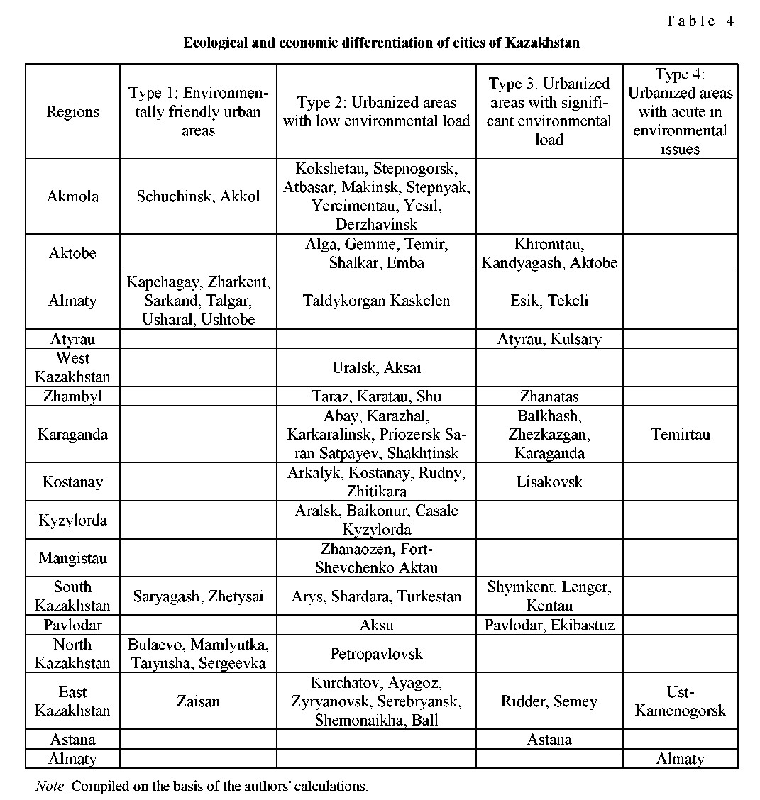
Table 4 shows cities by the degree of environmental attractiveness.
The first group of urbanized areas includes 15 small towns, with a total of less than 10 % of the urban population of Kazakhstan.
The ecological risk of development of these cities is low due to the lack of industrial production with a high anthropogenic load, the presence of favorable natural and climatic conditions, positively affecting the living and health conditions of the population.
The second group is the largest in its quantitative composition — more than 56 % of all cities in 49 small and medium-sized cities, by population — about 45 %.
The second group of cities is characterized by separate apparent environmental restrictions for the population.
For a number of cities, they can have a natural character, in particular, the threat of mudflows, floods, etc. For certain cities there are problems of high depreciation of utility networks, lack of sufficient sources of drinking water, and absence of solid waste landfills. A number of single-industry towns has environmental restrictions due to the narrowly focused specialization of a particular city-forming industry.
The third group is represented by 20 cities in Kazakhstan, where about 5 million people live. In these cities, there is «historical» environmental pollution, which require significant budgetary funds for their solution; there is a very high impact on the environment, atmosphere, water and land resources from industrial facilities.
The fourth group included 3 cities: Almaty, Ust-Kamenogorsk and Temirtau. Almaty has a high risk of mudflow and flooding, seismic activity, noted the problem of transport infrastructure and a high level of air pollution from vehicles. Ust-Kamenogorsk accounts for more than 40 % of all emissions, salvo emissions are frequent. And the sources of pollution (3 large metallurgical plants) are in the city, in the immediate vicinity of the residential zone, and Ust-Kamenogorsk is located in the lowland, surrounded by mountains, so all harmful substances remain in the city. In addition, the city has an unfavorable radiation situation. The main cause of radioactive contamination of the city is the waste from the debarking factories of the former «Kalbaolovo» trust. During the period of the operation of the finishing plants (1940-1950) in Ust- Kamenogorsk, there were no tailing dumps and special disposal facilities for storing tailings for the pro-
cessing of concentrates. In addition, the tailings of the finishing factories were located in factories, further dispersed in wastelands around the objects themselves, and were also used to fill ruts, repair ground roads.
Annually, industrial enterprises of Temirtau throw about 400 thousand tons of harmful substances into the air, in the same Ust-Kamenogorsk annual amount of emissions is 65-70 thousand tons.
In Temirtau, to date, the problem of safe storage and disposal of toxic waste has not been solved. The important problem of pollution of land resources is the excess of volumes of formation of wastes of metallurgical production over the volumes of their use. In the city of Temirtau, about 43-44 million tons of waste are generated annually (on average 70 % of the raw materials), more than 981,5 million tons have been accumulated. It can be stated that, unlike foreign enterprises, waste is not processed and accumulated on the territory of industrial facilities. Virtually the entire volume (99,9 %) of toxic waste on the territory of the reporting enterprises is waste of the 4th class of danger (extremely dangerous) — metal slags and slimes.
The main problem of water resources pollution is mercury contamination of the bottom sediments of the Nura River and the industrial site of the former JSC «Karbid» in the city of Temirtau. In 2003, Kazakhstan signed an agreement with the International Bank for Reconstruction and Development on the implementation of the Nura River cleanup project. The project cost was almost 98 million dollars. For the disposal of waste, a special landfill was built three kilometers from Temirtau. In 2011, the project was completed: more than 700 thousand tons of polluted soil was taken to the landfill site, from the floodplain of the river itself — 1 million 400 thousand tons. At the present time, a repeated contamination of the river with mercury is observed, due to the fact that the factory collector, where half a century of toxic wastewater was discharged, was not cleaned. This underground concrete box is more than 4 km long, all «saturated» with mercury, which during flash floods gets to Nuru, cleared for 100 million US dollars.
This method of environmental-economic differentiation is fairly simple to use. Its main advantage is the completeness of the picture of obvious environmental threats and the likelihood of this risk, which in turn can be the initial step in the formation of environmental policy based on corrective actions to manage environmental risks.
Thus, the methodological basis for the ecological and economic differentiation of the cities of Kazakhstan has been developed according to the following classification:
- environmentally friendly urbanized areas;
- urbanized areas with low ecological load;
- urbanized areas with significant environmental impact;
- urbanized areas with acute environmental problems.
References
- Ilinbaeva, E.A., Doroshenko, & S.V., Shelomentsev, A.G. (2015). Metodika otsenki ekolohicheskoho kachestva stratehii sotsialno-ekonomocheskoho razvitiia rehionov [Methods of assessing the environmental quality of socio-economic development of the regions]. Sovremennye tekhnolohii upravleniia – Modern control technology, No. 10 (58) [in Russian].
- Shekhovtseva, L.S. (2007). Metodika formirovaniia stratehicheskikh tselei razvitiia rehiona [Technique of formation of strategic objectives of development of the region]. Menedzhment v Rossii i za rubezhom – Management in Russia and abroad, No. 3 [in Russian].
- Lappo, G.M. (2012). Horoda Rossii. Vzhliad heohrafa [Russia Cities. A geographer's view]. Moscow: Novyi khoronohraf [in Russian].
- Tatarkin, A.I., & Nekrasov, A.A. (2015). Teoretiko-metodolohicheskie podkhody k otsenke stratehii horodov-millionnikov [Theoretical and methodological approaches to the assessment of strategies of million-person cities: the role of local communities]. Upravlenets – Manager, No. 1, 19–25 [in Russian].
- Kopylov, I.S. (2011). Printsypy i kriterii intehralnoi otsenki heoekolohicheskoho sostoianiia prirodnykh i urbanizirovannykh territorii [The principles and criteria for the integrated assessment of geo-ecological condition of natural and urban areas]. Sovremennye problemy nauki i obrazovaniia – Modern problems of science and education, No. 6 [in Russian].