Abstract
Flooding is one of the first places among natural disasters in terms of frequency, magnitude and annual damage to property'. Thus, the problem of timely forecasting of flooding of territories is actual today. One of the main tasks of flood monitoring is operational satellite imagery of the area, analysis of the flooded area, water level measurement, assessment of the scale of the disaster. In this case, geographic information systems have advantages in processing a huge amount of multidimensional data using digital maps. GIS can significantly simplify the system of forecasts and assessments of complex environmental impact, quickly identify anomalies, take the necessary' measures to eliminate them. They have a functional system and are easy to implement. This article discusses the problems and prospects of using geoinformation systems in the field of management. As an available program is taken ArcGIS, in which work is underway to create of interactive thematic maps forecasting flood zones on the example of the river Ishim.
Introduction
Currently, there is an increasing trend of occurrence of natural disasters on Earth, and, despite its level of development, humanity has not yet learned to fully timely predict and prevent natural hazards. The number of victims of natural disasters from year to year increases by 4.3%, and victims-by 8.6%. Economic losses increase by an average of 6% per year. Natural disasters in 2018 caused $160 billion in damage and killed 10,400 people worldwide. So, 2018 was the most unprofitable year in the last 38 years for insurance companies [1]. Today, everyone understands that natural disasters are a global problem that is the source of the deepest humanitarian shocks.
Of natural disasters, floods are one of the first places in terms of the frequency of the phenomenon, the area of distribution and annual material damage. In our country over the past 15 years there have been more than 300 floods of various origin, 70 % of them are caused by the spring flood. Annually in Kazakhstan about 300 thousand people suffer from floods, and the GDP of the Republic loses up to 3 billion dollars [2]. Such data were cited by analysts of the world Bank at the forum «Financing the risk of natural disasters» in Almaty.
The reason for such a frequent recent occurrence of floods in Kazakhstan, according to the Institute of geography of the International scientific complex «Astana» [3], is climate change, as for this reason, mean annual air temperature and annual amount of precipitation reaches its maximum performance, in addition you need to consider the fact of increasing numbers and density of the population living on the banks of rivers, laying of infrastructure (transport, energy, communication, water) objects along the rivers, regulation of rivers and the technical condition of the hydraulic structures themselves.
In our region, the most ambitious year in 37 years was 2017 in terms of its suddenness of occurrence and the number of victims. Flooding on the Ishim river was caused by a combination of several factors - the depth of soil freezing, rainfall and temperature. As a result, the water level in the river rises and the flood waters merge [4].
Floods as a natural disaster cannot be completely prevented anywhere and everywhere, they can only be weakened, localized and with timely warning to minimize material damage. It is necessary to take comprehensive measures to prevent or mitigate the consequences of floods (construction of hydraulic structures to regulate flow, the creation of protective dams, etc.) and timely notify the Ministry of emergency situations and residents about the threat and extent of flooding. In order to avoid undesirable developments, it is necessary to attract a large number of heterogeneous data coming from different sources (cartographic, aerospace, hydrological information), promptly process and analyze this information, and present it in a form that would ensure decision-making in a limited time frame [5].
Despite the fact that in the last decade there has been a rapid growth of information technologies and their widespread introduction in geographical Sciences, in Kazakhstan there is an acute problem in the use of GIS technologies in the assessment and analysis of the risks of emergencies. The tasks of forecasting and liquidation of emergency situations in our country remain at the traditional level. The problem lies in the use Ofinsufficiently rich tools in predicting emergencies, in the lack of special scientific research in Kazakhstan to determine the risk of flooding of territories, although this dangerous phenomenon due to natural and man-made causes annually leads to an increase in social tension and economic damage. In addition, there is insufficient material in the public domain, there is no availability of thematic maps of certain territories, and on the website of EMERCOM of North- Kazakhstan region just 1 map of the exposure area as the emergency situations Oftechnogenic character. Using GIS in forecasting will identify areas at risk of flooding, on the basis of which will create thematic interactive maps, recommendations and taken the necessary measures to protect these areas.
Organized in Almaty in May 2017 Fund «Soros-Kazakhstan» discussion of the experts pointed to the problem of fragmented management of water sector, explained that the issues supervised by different agencies (Ministry of agriculture, Ministry of energy, Ministry of interior), between which there is no proper coordination, and research of water issues in various ministries and are managed inefficiently [6]. Attention was also focused on the problems with hydrological forecasting - in the 1990s, the enterprise «Kazhydromet» closed most of the hydrological posts due to lack of funding, subsequently, as noted by the emergency Committee after the floods, there was an unreliability of the reports of «Kazhydromet». In addition, many noted that the country does not have a body that controls the state of hydraulic structures. Therefore, appropriate measures should be taken to prevent floods, not to eliminate the consequences. In our opinion, it would be rational to make a decision to create a comprehensive geographic information system for monitoring and forecasting natural emergencies.
When monitoring floods, one of the main tasks is operational satellite imagery of the area and timely analysis of the flooded area, changes in the water level, as well as the scale of the disaster.
In this case, the advantages of geoinformation systems are that they allow to analyze a large amount of multidimensional data using digital maps, as well as simplify the system of forecasts and assessments of complex environmental impact, quickly identify anomalies and take the necessary measures to eliminate them. A distinctive feature of the effective use of GIS is the presence of a functional system and simple implementation.
For example, in 2016, an overview of the elementary geoinformation system «GIS- Sputnik» was presented on the example of modeling the flood situation of a specific territory of the Ishim river - Voroniy island [7]. The figures below show the forecast model for this area.
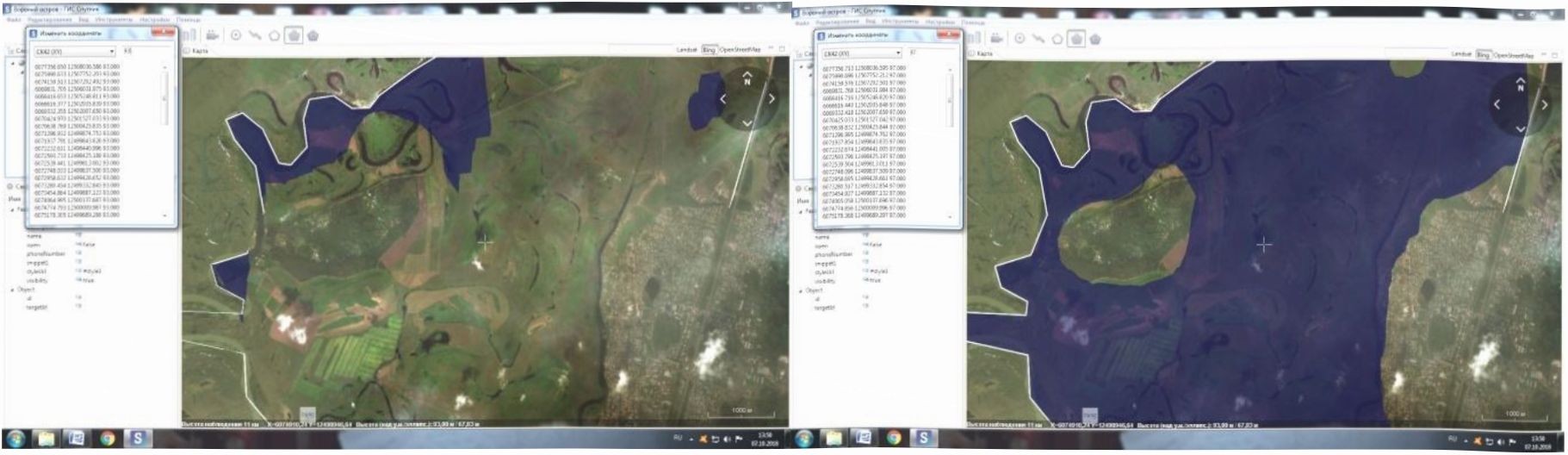
Figure 1 Scenario management of emergency situations in case of flooding of the territory
At that time, the program was publicly available on the Internet, everyone could go and predict the territory of flooding for their area. Today, this feature was removed from the demo version, making it paid.
Currently, we are working on the creation of interactive thematic maps of flood forecasting areas on the example of the Ishim river using the ArcGIS platform. ArcGIS is a complete system that allows you to collect, organize, manage, analyze, share, and distribute geographic information. Further, this data can be embedded in management processes and provide open access to use. The ArcGIS platform allows you to publish geographic information for anyone to access and use. The system is available at any point where it is possible to use web browsers, mobile devices in the form of smartphones, as well as desktop computers. As a world leader in platforms for building and using geographic information systems, ArcGIS is already being used by people around the world to apply geographic knowledge in the practical areas of government, business, science, education, and media. The geographic information system Of the national center for crisis management of the EMERCOM of Russia is also based on the Esri ArcGTS system [8]. And in Kazakhstan, corporate geoinformation systems are being developed on the basis of «Kazakhstan center of information technologies» LLP [9].
ArcGIS allows you to do the following:
- Create, share and use smart cards;
- Compilation of geographical information;
- Create and manage geographic databases;
- solving problems using spatial analysis;
- creating applications based on maps;
- Communication and exchange of information using the power of geography and visualization.
Conclusion
Thus, the advantage of geoinformation technologies in the processes of systematization, compilation and forecasting of natural disasters is undeniable. The use of satellite images in integration with the capabilities of the ArcGIS platform will allow to simulate the situation of the onset of floods, to make an operational forecast of the flood zones, to assess the scale of the situation and the damage caused. The use of geographic information systems is required including prediction of areas of inundation of the floodplain of the river Ishim. The forecasting methodology developed in the future can be implemented in the Ministry of emergency situations for timely adoption of necessary measures and prevention of catastrophic consequences.
References:
- Burlibaev, M. Zh. Hydrological natural phenomena (world trends, chronicle of Belarus and Kazakhstan) / M. Zh. Brwlibaev. A. A. Volchek, M. Yu. Kalinin // Water resources of Central Asia and their use, vol. 2.: abstracts of the Intern, scientific-practical. Conf., dedicated to summing up the results of the UN decade «Water for life». - Almaty. 2016. Pp. 372-377.
- A. Turkaev world Bank: the economy OfKazakhstan annually loses 3 billion dollars from floods // Electronic publication of 27.02.2019 - https://informburo.kz/novosti/vsemimyy-bank-ekonomika- kazahstan-ezhegodno-teryaet-3-mlrd-dollarov-ot-navodneniy.html.
- Hydrological computer modeling of the flood of the Esil and Nura rivers to determine the risk of flooding of the territory of Astana and adjacent settlements (2018-2020) http://isca.kz/ru/structure- ru/institute-of-geography-and-environmental-research/hydro-model.
- Sartin A. S., Khasenova A., Amantai S., Abilova G. Studying the prerequisites for the emergence of a flood situation on the Ishim river // Bulletin of the North Kazaklistan state University named after M. Kozybayev. No. 1(42). - Petropavlovsk: M. Kozybaevatyndagjr AKMU. 2019. - Pp. 52-56.
- Ramazanova N. E.. Zhusupova S. On the issue of flood forecasting in the river basin // Volga scientific Bulletin-2015. - No. 4-2 (44). - Pp. 103-105.
- Analytical group «Cyprus» // the Website of the company http://agkipr.kz/arcliives/1216.
- Dmitriev P. S. Forecast of flood waters of the Ishim river on the territory of «Voroniy island» using elementary' GIS technologies/ P. S. Dmitriev, I. A. Fomin, A. Yu. Levev. M. A. Zhagiparova, Zh. Zhumagulov // Ecological monitoring and biodiversity: proceedings of the all-Russian (with international participation) scientific-practical conference / Rev. ed. - Isliim: Ed. P. p. Yershov (branch) OfTyumen state University. 2018. - Pp. 21-24.
- Shcherbina S. Geoinfonnation system of the National center of management in crisis situations of EMERCOM OfRussia // Century of quality-2013. - No. 2. - Pp. 50-52.
- LLP «Kazakhstan Center of information technologies» // the Website of the company IittpsWgis- center.kz.